Notes on the Origins and Locations of Place Names
Newcastle - Lake Macquarie - Hunter Valley
M
Macarthur River - Flows into Gloucester River
Macquarie Farm - Farm belonging to Anthony Dwyer, Patterson's Plains 1828. Later purchased by W.M. Manning and then William M. Arnold. Known as Stradbroke.
Macquarie (Lake)- Co. of Northumberland, a large inlet of the sea connected with the Pacific Ocean by a narrow passage called Reid's Mistake. 20 miles in length; averages 3 miles in width. [37]
Macquarie Pier - Breakwater from Nobbys to the mainland
Macquarie Street - name given to Watt Street, Newcastle early in the settlement
Macqueen - Co. of Brisbane - a township on the Goulburn River to the S. of Moonan Brook. [37]
Macquoid - a mountain in Co. Northumberland near the Great North Road 80 miles from Sydney
Magonebay Island - Port Stephens - Dangar's map [29]
Maibenville House - Laman Street, Newcastle. The house of Robert Corbet Knaggs
Main Camp -Catherine Hill Bay - descriptive - there were three sections of the town - Main Camp, Middle Camp and Mine Camp [46]
Main Creek - Dungog - named after the creek which runs into the Williams River from the Monkerai Range [46]
Main Creek Farm - Dungog
Maison Dieu - 8 miles from Singleton. School for young ladies in 1842.
Maitland - After Captain Frederick Lewes Maitland R.N. who received the surrender of Napoleon Boneparte on H.M.S. Belerephon after his flight at Waterloo. In 1829 Maitland was established however the settlers on the land on the west side of Wallis Creek, then known as Wallis Plains, were not satisfied and wanted to have their own town. As a result of representations made to him Gov. Bourke, he acceded and the boundaries of the new town of West Maitland were defined. The area then known as Maitland was renamed East Maitland.
Maitland Gaol - John St. East Maitland
Malaraway - district of Liverpool Plains at Waterloo Creek. Station of John Eckford
Malgoorieyn - Kamilaroi - aboriginal for Edinglassie [39]
Mallabula - Port Stephens district [46]
Mandalong - Co. of Northumberland. West of Morisset
Mangoola - Muswellbrook district. Aboriginal meaning - a bird [46]
Mangrove Creek. Co. of Northumberland. Village situated on a creek flowing into the N. bank of the Hawkesbury River
Mangrove Island - Co. of Northumberland, a small island in the Broadwater, Brisbane Water.
Manilla - Run belonging to Richard Rouse at Liverpool Plains
Manilla - Co. Darling. Postal town situated on the Namoi River near the junction of the Manilla River in the district of Tamworth. [37]
Manilla River (Aboriginal Muneela meaning round about)
Mannering Creek - Co. of Northumberland. a stream rising in Mount Warrawolong and flowing into Lake Macquarie. [37]
Manning Mount - Co. of Northumberland - a high peak in the parish of Lockyer, on the W. side of the road from Maitland to Sydney via Wollombi. [37]
Manning River - Named by Robert Dawson the first agent of the A.A. Company in honour of the Deputy Governor of the company, Sir Herbert Manning
Manobalai Nature Reserve - created in July 1967. Muswellbrook district
Mardi - Wyong district - Aboriginal meaning - a stone knife [46]
Market Street - Newcastle
Marks Point - Belmont district. Named by Charles Marks after his brother Maurice who took up land in 1862 naming his area "Marksville" [46]
Marlborough House - 49 Church Street, Newcastle. Residence of Dr. May Harris
Marlee - Manning River aboriginal name meaning The Elder Tree. Postal village in Co. of Gloucester. [37]
Marmaran - near Pages Creek
Marmong - Lake Macquarie. Aboriginal meaning - a father [46]
Marmong Point - (Aboriginal meaning low water or swampy water). Lake Macquarie
Maroota - Aboriginal name for an area four or five miles from Wiseman's Ferry
Marrana Creek - Co. of Durham
Marrogoingan Island - Port Stephens (1826)
Martindale - Estate belonging to the Bettington family. Muswellbrook district
Martin's Creek - Named after Edward Martin who settled on the banks of the Paterson River near where the creek joins it in 1851.
Martinsville - Morisset district. Named after William and Sarah Martin. Colloquially known as The Brush
Marwood - Parish in Co. Durham bounded on the N. by Mirannie; W. by Sedgefield; E by Stanhope; and S. by the river Hunter.
Maryland - 1280 grant to George Brooks. Originally called Merrylands
Maryville (suburb of Newcastle) - After the wife of James Hannell M.L.A. Previously known as Smedmore
Maryville - situated in Co. of Hunter at Jerry's Plains. Residence of W.L. Russell. Formerly belonged to John Martin Davis
Matcham - Gosford district - named after Charles Horatio Nelson Matcham who in 1828 received a grant of 2560 acres [46]
Mattawee - Yellow Rock - near Broke (Mitchell's Map)
Maudville - Gloucester district - named after the daughter of J. A. Laurie, the owner of the property [46]
Maule - River situated in district of Liverpool Plains; flows into the Namoi
Mawson - Swansea district. Named after . A. Mawson, owner of the land [46]
Mayben Vale Estate - Murrurundi
Mayfield - (suburb of Newcastle) - After May Scholey one of the daughters of John Scholey a butcher of Newcastle who bought the area on April 2 1881 and had it subdivided
McCormack St. Newcastle - named after early merchant Thomas McCormack [3]
McCullys Gap - Muswellbrook district [46]
McDonald's Flat - Co. of Northumberland, lying 8 miles S of the Wollombi township on the Wollombi Brook
McDougall's Hill - Singleton district. Residents retreated to McDougall's Hill in floods (1826)
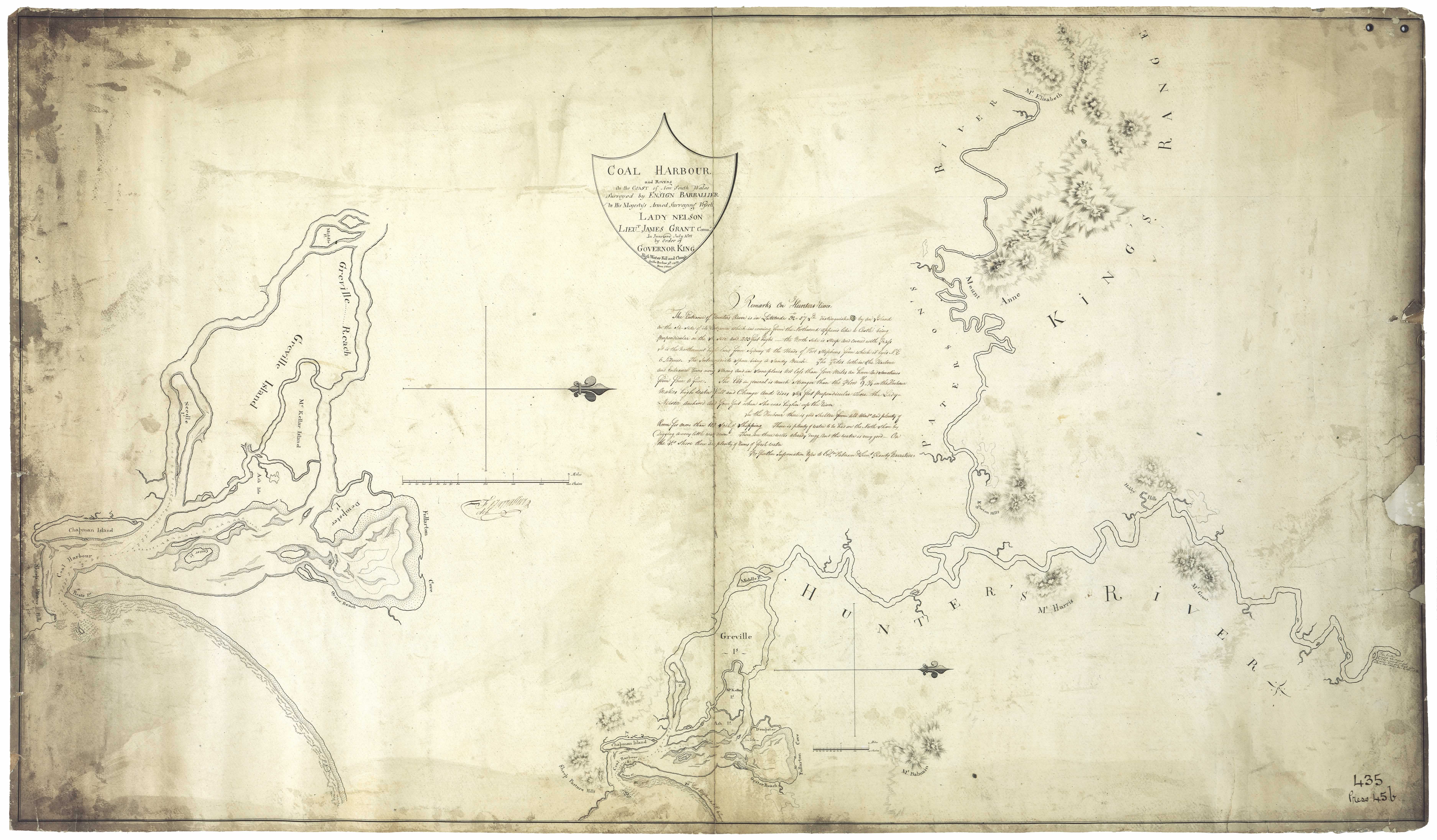
McKellar Island - Hunter River. Also known as Moscheto Island. Named after Ensign Neil McKellar. (see Barrallier's 1801 map for location
Medkin - district of Liverpool Plains on the Gwydir 300 miles from Maitland. Station of R. Fitzgerald
Medowie - Raymond Terrace district
Medway Estate - Four miles from Newport Lake Macquarie, 1840. Part of a grant to Mr. Osborne
Meerah - Grazing run of the Loder brothers on the Namoi
Meeroe - district of Liverpool Plains on the Namoi river. John Town's station
Meggoneby Island - Port Stephens (1826)
Melbee - Estate belonging to Duncan Forbes Mackay. Co. Durham
Melbourne - Parish in Co. Brisbane bounded on W. by Willis; S by Dartbrook; and E. by Kingdon Ponds.
Melbury - near Underbank, Williams River. Named after a place near Salisbury, England [46]
Melmerby Farm - 300 acres near Hinton
Melville - Grant to William Hicks. Purchased by Joseph Underwood in 1826.
Melville Peaks - Gloucester
Melville Street Newcastle - named after the Hon. J.T. Leslie Melville, one of the first directors of the AA. Co.. Early name for Union Street [3]
Mendip Hills - Paterson district, Parish of Wolsingham (Dangar's Map)
Merah - run at Liverpool Plains taken up by George and Andrew Loder
Merewether - named after Edward Christopher Merewether, Superintendent of the A.A. Co. Co. of Northumberland Incorporated a municipal district in 1885 with a council of 8 aldermen and a mayor. [37]
Merianborrough - station of Moses Joseph district of Liverpool Plains
Merindebrie - district of Liverpool Plains on the Peel river. Cobcroft's station
Merrigala - Grazing run on the Namoi River belonging to Sir John Jamison
Merrilong - Aboriginal name for Day's Hill, East Maitland (1860s)
Merriwa - Plenty grass seed (aboriginal meaning) [46]; or flour made from glass seeds by rubbing them between stones; town situated on Co. Brisbane on Gummum creek
Merriwa Creek - Co. of Brisbane - small northern tributary of the Goulburn River flowing pas the town of Merriwa. [37]
Merrumborough - Run belonging to Joseph Moses at Liverpool Plains
Mersheen - Grant to William Buchanan - Upper Hunter
Merton - Grant to William Ogilvie - Situated on Twickenham Meadows near confluence of the Goulburn and Hunter Rivers. Kamilaroi aboriginal name Buneewa
Metford - Maitland disrict - originally named Enfield as it was the site of the local rofle battalions but as that name clashed with a suburb of Sydney it was changed to another type of rifle [46]
Mibrodale - Estate belonging to John Howe on Parson's creek Co. Northumberland
Mibrodale - Co. Northumberland - an agricultural village on Wollombi Brook 10 miles SW of Singleton
Milbrodale - 23 km south of Singleton. Grant to Rev. Richard Hill
Middlebrook - Scone district [46]
Middlecamp - Catherine Hill Bay
Middlehope - Parish in Co. Durham bounded on the S. by the Hunter river; E by the Paterson river; N by Houghton; and W. by Wolsingham
Milegang - Estate/house - parish Wittingham (Dangar's Map)
Milgarra - located at Wybong Creek - estate of Archibald Bell
Milkingourie - district of Liverpool Plains on the Namoi river. John Town's station
Millboorum - Kamilaroi aboriginal name for Bell's Mountain in Muswellbrook district [39]
Milleree - In the district of Liverpool plains on the Barwon river. Station of C. Abercrombie
Millers Forest - Estate of Vicars Jacob - Named from its use as a timber supply for a miller on the river bank at Raymond Terrace [46]
Miller's Forest - Co. of Durham - postal town on the Hunter River parish of Alnwick 9 miles from Morpeth
Miller's Estate - Cardiff near Tickhole tunnel
Miller's Wharf - Cockle Creek
Millfield - So named because a flourmill was once situated there. Co. of Northumberland. Village situated on the Wollombi Brook
Mill Ford Farm - near Clarencetown
Millobee/ Milloba - Situated on the shores of Lake Macquarie. Later known as Speer's Point
Mindaribba - A hunter (aboriginal meaning) [46]. Near Old Banks, Paterson, Maitland
Minderibba - Aboriginal name for Maitland - Illustrated Sydney News 7 September 1878.
Mine Camp - Catherine Hill Bay - that portion of the town nearest to the mine [46]
Minimbah - The place of the teacher of the tribe (aboriginal meaning). Grant to John Cobb
Minmi / Minmai- (Aboriginal meaning - The home of the giant lily {Threlkeld} Minmi began as a cattle station in the 1830’s. Later a private town owned by J and A Brown. Situated in the parish of Hexham 6 miles from the Hunter River. [37]
Minnamurra - (Aboriginal meaning - by the waters) - Wangi (Israel's subdivision map c. 1923)
Minnibimbil - The grave of the teacher of the tribe (Aboriginal meaning)
Minyago yugilla - (Why weepest thou?) name of a fountain springing out of the side of a mountain near the Namoi
Mirannie - A camp (aboriginal meaning) [46]. Singleton district
Mirari Creek - Falling into the Allyn River near its junction with the Paterson River. Also known as Big Creek.
Mirrabooka - at Lake Macquarie. Aboriginal meaning the Southern Cross [46]
Mirra View - Morisset - aboriginal meaning - a camp [46]
Mitchell's Flat - Singleton district
Moani Rd - Wangi - aboriginal meaning kangaroo (Israel's Subdivision Map c. 1923
Moffatt's Swamp - near Raymond Terrace
Mogilmogil - district of Liverpool Plains on the Namoi river. Captain C.F.H. Smith's station
Mogo -Wollombi district - Aboriginal meaning - a stone hatchet [46]
Mohenia - Run at Liverpool Plains taken p by William, N.S.
Molly Morgan's Hill - Hill outside Greta named after Molly Morgan who ownded land there
Mondrock - Manning river aboriginal meaning The place of Frogs
Monilla - Run belonging to W.C. Wentworth at Liverpool Plains
Monkerai - Aboriginal name - grey gum tree. -
Monkerai - Co. of Gloucester. Village situated on the Karuah River. Aboriginal meaning - a grey gum tree [46]
Monkey Town - Teralba, Lake Macquarie
Monnybung - near Punby Brook, Parish Wolsingham (Dangar's Map)
Montebello House - Market Square Newcastle 1861
Montrose Park - Jerrys Plains. Estate of Edmond Doyle
Montyac Creek - small stream running into the Myall River (Teggs:1842); later known as Blackboy Creek
Monument Hill - Newcastle - Reservoir 500,000 gallons in 1889
Mooki - district of Liverpool Plains 36 miles from Murrurundi. Estate named after a fine spring situated 100 yards up the bank at the back of the house. Lease held by John O'Dell for Hawkesbury Benevolent Soc.,1840s. Managed by Mr. Meredith in 1887
Mooki Springs - run at Liverpool belonging to Isabella Holmes
Mooki River - (aboriginal Mook'i - flinty)
Moonan - Difficult to accomplish (aboriginal meaning) [24]
Moonan Brook - Co. of Brisbane, village siutated on the Moonan Brook or Bell's Creek an affluent of the Hunter River
Moonbi - A creek situated in district of Liverpool Plains. Branch of the river Cockburn
Moonbi - Lease of Henry Dangar 25,600 acres
Moonbi - Co. of Inglis - postal town situaged on the Moonbi Creek at the foot of the Great Moonbi range of mountains . Distance from Tamworth 12 miles.
Moonbil (now Aberdeen) Green head Ant (aboriginal meaning) [24]
Moonboy - district of Liverpool Plains on the Cockburn river 10 miles from Tamworth. station of Henry Dangar
Mooney Mooney - Gosford district - Aboriginal meaning - very sick or many sick [46]
Moonibung Hill Nature Reserve - East of Paterson. Approx 2900 acres [42]
Moon Island - Swansea - Thought to have played a part in the Captain William Reid's mistake which led to the discovery of Lake Macquarie. Small rocky islet lying at the entrance of Lake Macquarie. [37]
Moorabie - run at Liverpool Plains taken up by Nelson Simons Lawson
Moorlarben Creek - Co. Bligh - one of the heads of the Goulburn River. [37]
Moorkadool - district of Liverpool plains on the Barwon river. Helens Scott's squattage
Mootaior Mooti - Cessnock district. Aboriginal meaning - an opossum [46]
Morandoo - Port Waratah site of B.H.P. Co Steelworks. Aboriginal meaning - the sea [46]
Morduval - Quirindi district - Aboriginal meaning - a hanging bush in a tree [46]
Moreton Bay. In 1848 a squatting district of NSW
Moreton Farm - Hunter River
Morgan St. Merewether - Names for Mr. Morgan who arrived in Newcastle in 1850 to manage the copper smelting works of Dr. James Mitchell
Morgan St. Newcastle - named after Dr. C.W. Morgan, Mayor of Newcastle [3]
Morisset - Co. Northumberland Lake Macquarie. Named after Major J. T. Morisset, Commandant of Newcastle 1818 - 1823, who passed through on his historic trip from Newcastle to Sydney in nine days in 1823 [46]
Morna Point and Bay - Co. of Durham, a rocky promontory and sandy bight to the N. of it, lying a few miles S. of Port Stephens. [37]
Moroney ave Newcastle - named after Alderman M.J. Moroney, Mayor of Newcastle [3]
Morpeth - also known as Green Hills - after a place in Northumberland in the north of England. Aboriginan name Illalung. Situated Co. Northumberland
Morton's Creek - Co. of Northumberland - a village near Hexham. [37]
Moruben - Mountain in Yengo National Park
Moscheto Island - island in the Hunter River now forming part of Kooragang. Once known as McKellar Island after Ensign Neil McKellar. Named after Tony Moscheto, a fisherman [46]
Mosey's Beach - Nords Wharf
Mosquito Island - also known as Moscheto Island. Situated Co. of Northumberland, a large island in the Hunter River 5 miles W of Newcastle and separated from Ash Island by a narrow channel. [37]
Moss Cottage - Stoney Creek, Maitland
Motto Farm - Charles Croaker. Aboriginal name 'Mutah' meaning black snake
Moto - Manning River aboriginal name for black snake
Mount Anne - Paterson River (See Barralliers 1801 map)
Mount Arthur - (Whites Sugar Loaf) Kamilaroi aboriginal name Cullarraba
Mount Aubin Estate - Wollombi - Richard Wiseman
Mount Breezer - district of Liverpool Plains on the Mooki river. Squattage of Andrew Lang
Mount Carrow - In the Mount Royal Ranges, Hunter Valley
Mount Cobrabold - Also Cobre Bald. In the Mount Royal Ranges, Hunter Valley
Mount Cupula - see below
Mount Dangar - After Henry Dangar, Surveyor to the A.A. Company. Vicinity of Denman. Mount Dangar was sighted in 1824 by surveyor Henry Dangar, who named it Mount Cupola (for its domed shape). It was renamed by explorer Allan Cunningham, who became the first European to climb it the following year.
Mount Dyrring - Also. Dyrinne, Deren, Dyring. Upper Hunter near Singleton
Mount Elizabeth - On Barraliers 1801 map Mount Elizabeth situated at (r) bank Hunter River at Beresford Hudson's 'Donnybrook'.
Mount Finch - near Wollombi Brook, Co. Northumberland. (Mitchells Map)
Mount Johnstone - near Vacy - see Dangars map [29]
Mount Joye - Estate of Ferdinand Anley situated on the Williams River. The estate of Clark Irving in 1848
Mount Kanwary or Kenwary - original Mt. Kenworthy after Lieut. Kenworthy who was attached to the garrison at Newcastle. Williams River district
Mount Kindarun - Singleton district. Putty Creek, or the Tupa, rises in north at the foot of Mt Kindarun, and runs the length of the valley before joining with the Wollemi Creek which then feeds into the Colo River
Mount King - Situated on the Irrawang estate
Mount Lockyer - Mountain southeast of Mogo Hill
Mount Manbus - near Thornthwaite. Co. Brisbane
Mount Manobolar - Co. Brisbane
Mount McKinlay - The estate of Ellar McKellar McKinlay at Dungog
Mount Moan - Highest peak of the Liverpool Range
Mount Mulberry - Toronto - Name given to Threlkeld's second mission house
Mount Murulla - Cone shaped mountain in the Liverpool Ranges
Mount Narroul - Williams River district (Teggs: 1842)
Mount Olive - Singleton district
Mount Oxendale - Co. Durham. Near Omadale Creek
Mount Pleasant - Pattersons' Plains. Farm belonging to Robert Whitmore 1820s
Mount Pleasant - Singleton District
Mount Royale - A mountain situated in Co. of Durham; from this mountain the Allyn and Paterson rivers take their rise
Mount Royal Range - Co. Durham - a branch of the Liverpool Range, commencing near the Hanging Rock. [37]
Mount Simpson - named after Lieut. Percy Simpson in charge of construction on the Great North Road
Mount. Thorley - After Philip Thorley who with John Howe and Benjamin Singleton discovered Patrick Plains 17 March 1820 [46]
Mount Tomalpin - known as Tumblee
Mount View - Cessnock district
Mount Vincent - Co. of Northumberland - village 109 miles N. of Sydney
Mount Warrawolong - mountain west of Lake Macquarie named by Major Mitchell in 1831
Mount Windeyer - Williams River district (Teggs: 1842)
Mount Wingen - Scone district. Aboriginal - place of burning or fire [46]
Mowbray Estate - Paterson. Formerly known as The Vineyard. George Jackson Frankland
Muammba - Co. Northumberland - a small agricultural village at Patrick Plains. [37]
Muck Mount - Co. of Parry - a lofty peak in the Liverpool Range. [37]
Muddy Lake - Swamp/fish breeding ground at the mouth of Dora Creek near Eraring
Mudies Creek - Singleton district - named after James Mudie who received a grant which he named Castle Forbes [46]
Mulbring - The big mountain (aboriginal meaning) [46]. Co. Northumberland. Village 109 N of Sydney. Cessnock district
Mulbring Creek - a small western tributary of the head of Wallis' Creek
Mukibundie - district of Liverpool Plains on the river Gwydir. Baldwin's station
Mulconda Farm - Bandon Grove
Mulimbah - The house of Simon Kemp on the corner of King and Wolfe Streets Newcastle
Mullenroo - Gresford district. Aboriginal meaning - the meeting of the waters or a place of many creeks [46]
Mullug-bula - the name of two upright rocks about nine feet high springing up from the side of a bluff head on the margin of Lake Macquarie; Beneath the mountain on which the two pillars stand was a seam of coal from which Reid obtained a cargo of coals when he mistook the entrance of Lake Macquarie for Newcastle
Mulubinba or Mulumbimba - An indigenous fern (aboriginal meaning). The site of Newcastle [47]
Muluerinde - a river situated in district of Liverpool Plains empties into the Peel River near Wallumburra
Mundebry - district of Liverpool Plains on the Peel River. 28 miles from Tamworth. Cobcroft's station
Mundoie - Aboriginal meaning the foot - A chain of waterholes near Singleton running at the foot of a long range of hills.
Mundowie - Liverpool Plains. Station of the Fleming family in 1830s
Mundrook -Gloucester district - Aboriginal meaning a place of frogs [46]
Mungi Bindi - Station on the Gwydir River belonging to William Newsham
Mungyir - station of Richard Hill, district of Liverpool Plains
Munibung Hill - earlier known as Brooks' Mountain. Overlooking Lake Macquarie Taking in suburbs of Macquarie Hills, Boolaroo, Speers Point and Warners Bay. Possibly Aboriginal word meaning fruit.
Munmorah - Central Coast NSW - aboriginal meaning - a quiet place
Munmurra - Cassilis district. Aboriginal meaning - A moonblind blackfellow [46]
Munni - Grant of 1920 acres to John Mann - Williams River
Munni - Aboriginal name for Dungog district - means a good hunting ground. An alternative meaning - to be sick [46]
Munnimbah Brook - a stream situated in Co. Northumberland 123 miles from Sydney. Estates Rusholm and Castle Forbes nearby -see also Dangar's Map [29]
Munimbah - Estate of Robert Adamson Rodd
Munmurra Brook. Co. Bligh, a northern tributary of the Goulburn River flowing through the town of Cassilis.
Munnimbah Creek - Co. of Northumberland - a small southern tributary of the Hunter River rising near the township of Broke. [37]
Munro's Creek - Co. of Parry, a small auriferous tributary of the Peel River joining in at Bowling alley Point diggings. [37]
Munug - gurraba - place to which sea snipe resort
Munukan - name of a point under which is seams of cannel coal jut into the ea. (1834) - Threlkeld[21]
Murdering Gully - also called Burwood Gully (aboriginal name Kona-Konaba)
Murkadool - Run at Liverpool Plains belonging to Helenus Scott
Murulla - A meeting place (aboriginal meaning)
Murraman and Dural - Run belonging to John Wild at Liverpool Plains
Murray's Run - early grant to Andrew Murray at Wollombi Brook
Murray St. Newcastle - named after Bishop Murray [3]
Murrumbo - Stony ridges
Murrurundi - Five fingers (aboriginal meaning referring to the five peaks surrounding the town)[46]. Situated on Pages river .Co. of Brisbane. [24]
Murulla - Co. Brisbane - a village on the bank of the river Page opposite Blandford
Murulla Mount - a mountain situated in County Brisbane at the head of Kingdon Ponds 4 miles S of Murrurundi
Musquito - a creek in the district of Liverpool Plains; on this stream was the station of Dr. Gill
Musquito Town - Co. of Northumberland, a village in the parish of Kincumber 10 miles E. of Gosford
Muswellbrook - So called because of the quantity of mussels found in the vicinity in the early days. Lieut. Grant in his Journal of 1801 writes 'the ground was covered with freshwater shells of the sort found in the rivers of England and Scotland and called the house mussel' [46] (Kamilaroi aboriginal name Bimboorien)
Muswellbrook - An alternative is that Muswellbrook was named after Muswell Hill in England where Sir Francis Forbes attended school. The name was altered from Muscle Brook to Muswellbrook in 1838
Muscle Creek Kamilaroi aboriginal name Gyarran
Myambat - A native dwelling (aboriginal meaning). Muswellbrook district
Myall - A stranger (aboriginal meaning); A lake in Co. Gloucester at entrance of the Myall river. The river empties into Port Stephens harbour
Myall Creek - a creek in Co. Durham which flows into the Williams River
Myall Creek - district of Liverpool plains. On this stream is the station of Henry Dangar
Myall Lakes National Park - Situated between Port Stephens (Yacaaba Head) and Smiths Lake
Myall Ranges - early name for the Watagan Mountains
Myambat - Denman district - Aboriginal meaning a native dwelling [46]
Myan - Aboriginal name for part of the the Hunter River [39]
Myrtle Cottage - Early building at Islington
Myrtle Villa - Residence of W. K. Lochhead near the obelisk at Newcastle
Myuna Bay- Clear water (aboriginal meaning) [46]. Near Eraring, Lake Macquarie. On early maps the bay was named Pantaloon Bay.
Notes on the Origins and Locations of the Hunter Region has been derived from the following sources
[1] Trove - National Library of Australia
[2] Newcastle Morning Herald 11 December 1954
[3] The Newcastle Sun 2 May 1918
[4] The Newcastle Sun 26 January 1931
[5] The Many names of Newcastle Mulumbinba
[6] The Muswellbrook Chronicle 8 November 1899 ( native names of place from black tracker Jimmy of Muswellbrook)
[7] Lake Macquarie History of Places
[8] Cadell, F.A., Survey of Newcastle, Journal and Proceedings of the Royal Australian Historical Society, 1936
[9] Davies, Noel, Convict Nobbys : the story of the convict construction of Macquarie's Pier and the reconstruction of Nobbys Island
[10] Historical Roads of New South Wales
[11] Keith H. Clouten, Reid's mistake : the story of Lake Macquarie from its discovery until 1890
[12] County Electors in Newcastle 1855
[13] Hunter Estates Comparative Heritage Study
[14] The Dungog Chronicle 6 July 1949
[15] The Scone Advocate 24 July 1894 (Muswellbrook names)
[16] Wingham Chronicle 13 November 1931 (Manning River places)
[17] King Tom's Aboriginal Geography in Memorandum of E.C. Close, in Australian Town and Country Journal, 12 January 1878, p. 8.
[18] Aboriginal names, Australian Town and Country Journal 11 January 1879p. 17
[19] Henry Thomas Ebsworth papers, June 1825-February 1827; with illustration and maps
[20] Horsemen of the First Frontier (1788-1900) and the Serpent's Legacy Front Cover Keith Robert Binney
[21] An Australian Language as spoken by the Awabakal, the people of Awaba, Lake Macquarie, being an account of their language, traditions and customs - Lancelot Threlkeld (many of the aboriginal terms above have come from this source which is probably the language of the lower Hunter tribes)(many of the aboriginal terms above have come from this source which is probably the language of the lower Hunter tribes)
[22] Hunter Living Histories - Ludwig Leichhardt in Newcastle
[23] A geographical dictionary or gazetteer of the Australian colonies ... By William Henry Wells
[24] Placenames as a guide to language distribution in the Upper Hunter - Jim Wafer
[25] Lake Macquarie : past and present
[26] Wangi Wangi Street Names by Clive Read
[27] Forgotten place names of Lake Macquarie - Lake Macquarie Library online
[28] Lake Macquarie: Parish of Awaba, County of Northumberland, Shire of Lake Macquarie. Parish map in 4 sheets and reference sheet: South East Sheet
[29] Map of the Hunter River and its branches by Henry Dangar 1828
[30] Robert Dixon's 1837 Map - Trove
[31] Ensign Francis Barrallier's Map 1801 - Hunter Living Histories
[32] Australian Town and Country Journal 22 November 1873
[33] Procter's Sketch 1841 - Hunter Living Histories
[34] Tegg's Pocket Almanac
[35] Map of Young Wallsend (Edgeworth) showing Salty Creek Recreation Area, c.1920. Scanned from: Road and tourists' map of Lake Macquarie and environs, H. E. C. Robinson Limited, Sydney.
[36] Salty Creek Recreation Area
[37] Geographical Encyclopaedia of New South Wales
[38] Atlas of the settled counties of New South Wales - State Library NSW
[39] Maitland Weekly Mercury 4 July 1896
[40] Empire 3 Dec 1853 Lecture on the Kamilaroi Blacks (Rev. William Ridley)
[41) Israel's subdivision map of Wangi c. 1923. State Library of NSW
[42] Hunter 2000, National Trust of Australia (NSW), 1973
[43] Lauchland, E. S., Homes we Visited - Dumore. Newcastle & Hunter District Historical Society Journal, 1947 p. 39
[44] Boyle's Lower Hunter index, 1801-1883 (Harry Boyle)
[45] Hunter Valley Place Names and their Meanings, Newcastle Library, Archived 14 June 2011 at the Wayback Machine
[46] Toponomy: Place Names of New South Wales: Their Origin, Meaning and Locality, compiled by J. Carlos W. Stretch
[47] Rediscovering the Coquun: towards an environmental history of the Hunter River. Address given at the River Forum 2000 at Wyndham Estate, Hunter River; by Glenn Albrecht PhD, Senior Lecturer in Environmental Studies, The University of Newcastle
[48] How Many Inventors? Russell Rigby, Hunter Living Histories, 10 October 2017
↑