Notes on the Origins and Locations of Place Names
Newcastle - Lake Macquarie - Hunter Valley
G
Galathra - Run belonging to W.C. Wentworth at Liverpool Plains
Galgabba - Aboriginal name meaning a place far away, for an area at Pelican's Flat, near Swansea [46]. Residence of Thomas Boyd in 1880
Gallagher's Mountain - near Turanville
Gammon's Plains - Co. of Brisbane 150 miles from Sydney. Near the township of Merriwa. [37]
Gangan - Stockton district. Aboriginal meaning - the top of surface of the sandhills or of a precipice [46]
Gangat - Gloucester district - Aboriginal meaning - a fish hawk [46]
Gaol Hill - Newcastle. Site of the Old Gaol. Situated at the beach end of Scott Street Later a tram depot.
Garden Suburb - Gordon Avenue area of Hamilton
Garden Suburb - North of Stockton. Also known as Corroba
Garawantara - any plain, a flat
Garewagal (Geawegal)- native land/people on sea coast and Hunter River
Garland Valley - Singleton district
Garrangola - (Goorangoola) a creek in Co. Durham. Branch of Fallbrook
Garside Gardens - King Edward Park. Named after Bob Garside who was superintendent of parks and gardens at Newcastle
Gaspard - Quirindi district [46]
Gateshead - named after a suburb of Newcastle-on-Tyne, England [46]
Gearywah - Manning River aboriginal meaning the iguana. Black Head the seaside resort
Geawegal - native language Hunter River
Gee's Crossing - near Ravensworth
Genena Hill - early name for Violet Hill at Myall Lakes
George The Barber's Stockyard - Grazing run on the Namoi belonging to Sir John Jamison
Georgetown - Originally called Geordie Town. Suburb of Newcastle named after George Moate who acquired land in the area in 1853. Adjacent to Hanbury (Waratah)
Geraldine Cottage - Singleton - Built in 1847 and once served as the Anglican school and parsonage
Giant Creek- a creek in Co. Brisbane; it flows into the river Goulburn
Giant's Leap - high country above Giant Creek - Dangar's Map [29]
Gibbagunyah Creek (aboriginal meaning house built of stone, shallow cave). West of Scone [24]
Gibbers, The - A headland on the coast opposite Broughton Island
Gilcoobil - (Kickerbill)- station of A and J. Blaxland in district of Liverpool Plains
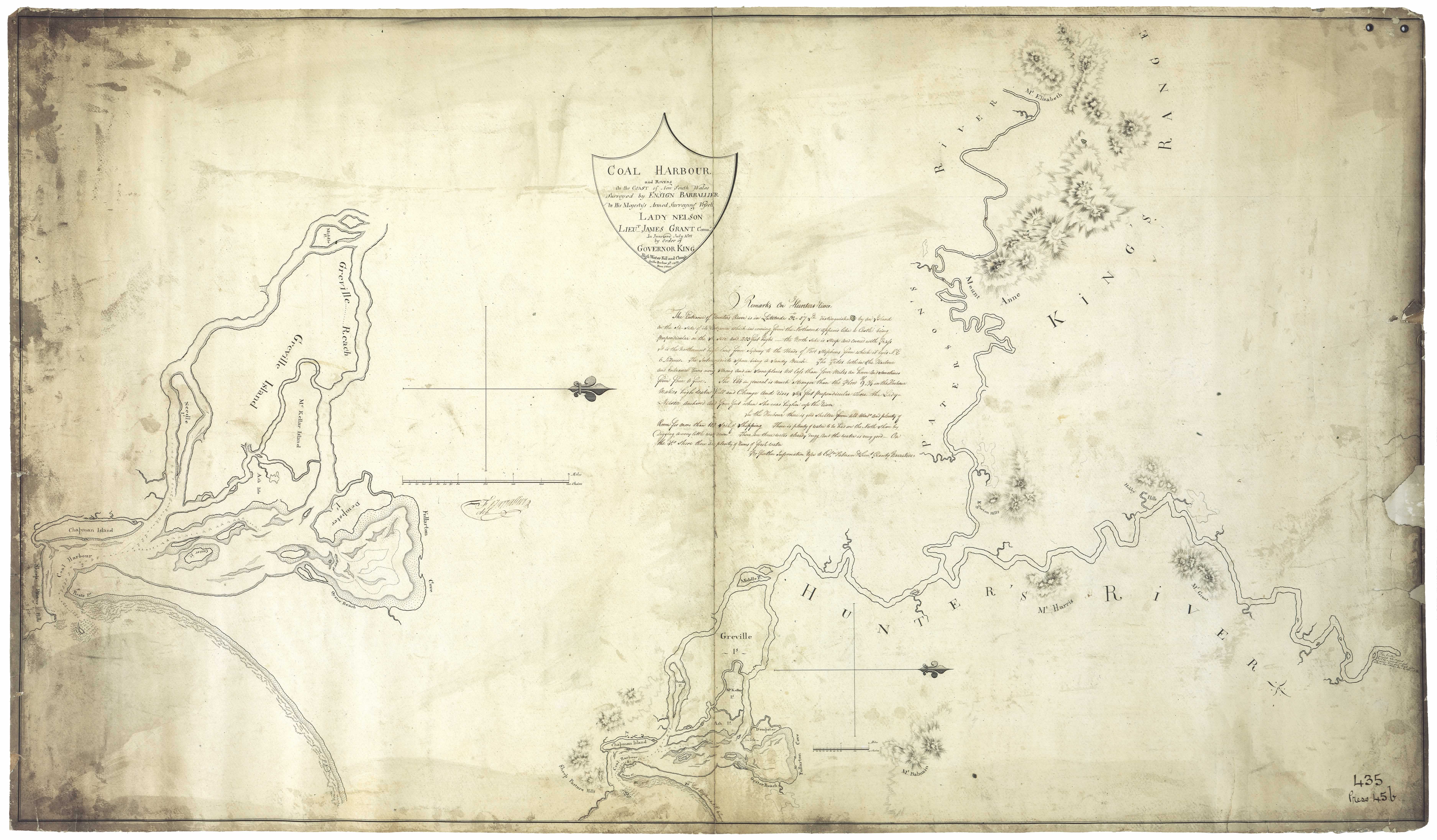
Gilgandra - Kamilaroi aboriginal name Geelganderra meaning youth who had gone through the third bora ceremony
Gillieston - After John Gillies, Mayor of West Maitland 1888
Gineroi - district of Liverpool Plains on the Gwyder river. 280 miles from Maitland; Galley's station
Gingamboon (Kingimbon) Hunter River [24]
Ginger - Run at Liverpool Plains taken up by Nelson Simmons Lawson
Ghingi - mountains
Giant Creek - Flows into Sandy Hollow
Gircobill - situated in district of Liverpool Plains, 22 miles from Gammon Plains
Giro - Gloucester district. Aboriginal meaning a black satin bird [46]
Girriwillie (Garrawilla) - Namoi River. Squattage of Charles Purcell, son of John Purcell, one time Commandant at Newcastle
Girvan - Booral district - named after a place in Ayr, Scotland [46]
Glandville - another name for Ash Island
Glebe Farm - Newcastle, Peter Flemming
Glebe Cottage - West Maitland 1844 Glebeland - Co. Northumberland, a village 2 miles from Adamstown [37]
Glenalbion Estate - Situated on the Paterson River
Glenalvon - Murrurundi. Estate of Peter Brodie 1840s. Later acquired by the White family
Glenarm Estate - Williams River four miles from Seaham. Estate of Mr. Clode 1857
Glencairn - Upper Hunter Valley. Also known as Cressfield, the estate of Archibald Little
Glendon - Co. Durham on Glendon Brook near Singleton. Named by Robert and Helenus Scott after their home in Scotland
Glendon Brook - Co. Durham. The Brook is a fine stream rising in the Mount Royal Ranges flowing into the Hunter River between Maitland and Singelton [37]
Glendor - Farm of John Thomas on the swamps near Wallsend
Glendon Farm - Farm of W.B. Fenwick near Newcastle in 1840s
Glenhunt - Estate adjoining Ravensworth owned by Bourn Russell
Glenlivit Estate - Williams River. 1500 acres. One mile from Clarencetown
Glen Martin - Clarence Town district [46]
Glenoak - Clarence Town district [46]
Glen Mitchell - name given to Quigley Estate, Lake Macquarie
Glen Musa - farm at Big Redhead owned by Mr. Bailey in 1870s
Glennies Creek - After James Glennie, early settler
Glenridding - situated in Co. Durham on Hunter river near Maitland. Grant to John Earl
Glenrock - property belonging to Alexander Campbell at Barrington Tops
Glenrock Lagoon - south of Newcastle. Also known as Valley of the Palms. Later Burwood. Nearby as Wahrah on Dangar's 1828 map
Glenrose - Farm of Rev. George Augustus Middleton - Paterson
Glenthorne - Estate of Rev. Alfred Glennie three miles from Charles Boydell's Camyrallyn, Paterson district. In 1865 3 acres under vine owned by Gilbert Champain
Glenview Farm - 4 miles from Raymond Terrace
Glen William - Co. Durham - postal village on the Williams River 5 miles from Clarencetown. [37] Named for William, Duke of Clarence, who later became King William IV [46]
Gloucester - After the Cathedral city in England - River and County in NSW
Glupton - Co. Brisbane, township 232 miles N. of Sydney. [37]
Gnoolooma - run belonging to Joseph Pearse at Liverpool Plains
Goat Hill - Pittown area of Wallsend
Goat Island - (native name Memel) an island situated at the mouth of the Parramatta River in the harbor of Port Jackson
Goat Island - small island in the Hunter now part of Kooragang
Goat Island - in Lake Macquarie
Gola - Kamilaroi aboriginal name for Overton estate [39]
Goloyauwe - a point of land on the south side of the Lake
Goo-a-rinda - Grazing run of George Thomas and Andrew Loder at Quirindi Creek
Goodar - Run at Liverpool Plains taken up by James Marks
Goomawidyera - Kamilaroi name for Dart Brook [39]
Goonal - district of Liverpool Plains on Waterloo creek; Thomas Brown's station
Goonda Point - at Wangi - Aboriginal word meaning fire or star (Israel's subdivision map c. 1923)
Goonoo-goonoo - Co. Parry. 360,000 acres selected and settled in 1834 on a river later known as the Peel. The settlement became the foundation of the city of Tamworth. District of Liverpool Plains on the Goonoo-Goonoo Creek near the Peel River being a gold mining district on that river. [37]
Goonoo Goonoo Creek - a southern tributary of the Peel River rising near the township of Goonoo-Goonoo and flowing into the Peel at Tamworth. [37]
Goonou - a river in district of Liverpool Plains. Branch of the Peel river
Goora - On the peel river in the district of Liverpool Plains
Goorable - in the district of Liverpool Plains on the Gwyder River 300 miles from Maitland. Station of Andrew Blake.
Goorangoola - (also Garrangola). Co. Durham. A bend in the creek. (aboriginal meaning). Estate owned by Robert Dawson
Goorangoola Creek - a small tributary of the Falbrook fed by the Campbell's Creek. [37]
Gorian - Run belonging to Joseph Pearse at Liverpool Plains
Gorriagilla - run at Liverpool Plains taken up by John McDonald
Gorroinba - the female emu place
Gosford - Co. Northumberland. Situated on an inlet of the sea from Broken Bay calld the Broadwater. Tuggerah Lake lied 9 miles north. [37]
Gosforth - Parish in Co. Northumberland bounded on the N. by Hunter River; W by Branxton and Allandale; S by Heddon and E. by Maitland
Gostwyck - Estate of Edward Cory at Paterson River.
Goulburn Grove - Estate of Standish Lawrence Harris. Situated Co. Durham at the junction of the Hunter and Paterson Rivers. Known as Trafalgar in 1848
Goulburn River - discovered by Lawson and Scott in 1822 in their endeavour to reach the Liverpool Plains. They named the river after Major Goulburn, the Colonial Secretary.
Gouldsville - Singelton district. Named after the pioneer family of Gould, timber millers [46]
Government Garden - Pacific St. Newcastle near intersection of Reid lane area overlooking the Newcastle surf club pavilion.
Gowrie - Singleton district
Grassy Haugh Estate - Henry Fisher, Black Creek
Grass Tree - Co. Durham. Muswellbrook district. 173 miles from Sydney. Descriptive of the large size and numbers of grass trees [46]
Gravel Pits - Teralba; Freshwater Creek
Gravesend - Cattle Station near Warialda, Gwydir District (1888)
Great Lodge - Estate of Richard Hobden - Hunter River
Green Hill - name given to by Lieut. Shortland to Raymond Terrace
Green Hill Farm - Farm belonging to David Davis at Wollombi
Green Hills - Estate of Edward Close. Later known as Morpeth.
Greenaway's Creek - near Raymond Terrace
Greenlands - Singleton district - named by the Postmisstress Miss Jane Kermode about 1910 in contrast to Greylands, a place close by [46]
Greenland Farm - Estate of Greenway family 1828
Green Wattle Estate - 1280 acres 4 miles from Hinton 1843.
Greenwood Estate - Situated near Singleton on the South West side of the Maitland to Singleton Road. Estate of G.H. Green
Greigs Creek - Named for Robert or his cousin James Greig - A creek situated in the county of Hunter also known as Burreen Creek. Flows into the Hunter River.
Gresford - Co. Durham. After a town on River Allyn, near Chester England. Situated on the Paterson river 1 1/2 miles from the Allyn River. [37]
Greta - village situated in Co. Northumberland on Black creek between Maitland and Singleton. 11 miles W. of Maitland
Gretamain - Cessnock - so named because the coal mine worked the main Greta seam [46]
Greville Island - Island in the Hunter River named after Charles Francis Greville by Ensign Barrallier. Also known as Ash Island. [31]
Grey's Creek. Co. Hunter. A southern tributary of the River Hunter. [37]
Grossman House - located at Maitland - one of two mirror image, Victorian Regency properties, built side by side on the same lot in 1870-71 for the prosperous business partners, Isaac Beckett and Samuel Owen.
Grove Cottage - Allyn River. Residence of Hopson and Miles
Grovetown - early name for Waratah Guangua Creek - Co. Brisbane, an eastern tributary of Wybong Creek.
Gully Line - name given to a railway line owned by Caledonian Collieries. Ran from Charlestown gully and crossed Lambton Rd at Broadmeadow. Original name Raspberry Gully
Gulong Mount - Co. Northumberland - a high peak in the Hunter Range in the parish of Blaxland and to the SW of Wollombi township. [37]
Guluthrea - district of Liverpool Plains 138 miles from Murrurundi. Squattage of W.C. Wentworth
Gummum - a creek situated in Co. Brisbane. Empties into the Goulburn river.
Gummum Plains - Merriwa district. Watered by Merriwa creek
Gum Tree Hole - Singleton district
Gunady - District of Liverpool Plains on the Mooki river 68 miles from Murrurundi; J. Johnston's station
Gunadaddy - district of Liverpool Plains on Gunnunderry creek at Mallalay Plains. Station of A. Denison
Gunandelly - district of Liverpool Plains on the river Mooki. Allen's station
Gundalia - 2 miles from Terrabi on the Barwan River [40]
Guangua Creek - Co. Brisbane. Flows into Wybong Creek
Gundamine - district of Liverpool Plains on the Namoi River 130 miles from Murrurundi. Station of Campbell and Ryan.
Gunderman - a creek situated in Co. Northumberland; flows into the Hawkesbury river.
Gundibri - on Gungal or Hall's Creek near Merton. A grant to Rev. John Dunmore Lang. Later owned by George Hall
Gundy - (Gunda) A camp (aboriginal meaning). Situated Co. Brisbane on the Page's River
Gundy Gundy - A parish in Co. Brisbane bounded on the S. by Macqueen; E. by Pages River
Gunerai - Run belonging to George Gally then James King at Liverpool Plains
Gungal - situated in Hall's creek in the county of Brisbane. Aboriginal meaning Bullrushes
Gungalla. As above. Aboriginal meaning rushes.
Gunnedah - (aboriginal - Goono dha) meaning a poor or destitute man. Namoi River. Alternative meaning Many white stones.
Gunygudah - a creek in district of Liverpool Plains. On this stream is the station of George Bowman situated 100 miles from Murrurundi.
Gurby - District of Liverpool Plains at Waterloo Plains 165 miles from Murrurundi. Station of the Bank of Australasia
Gurranba - a place of brambles
Guygallon Estate - Owned by James Webber - Paterson River
Gwandalan - Lake Macquarie; (aboriginal meaning haven of rest, quiet and peaceful waters)
Gwydir (or Kindur); a river in the district of Liverpool Plains. (aboriginal Gu-i-da meaning place of red (banks)
Gwydir - district of Liverpool Plains on the Gwydir river 30 miles from Armidale. James Hale's station
Gyarran - Kamilaroi aboriginal for Muscle Creek [39]
Notes on the Origins and Locations of the Hunter Region has been derived from the following sources
[1] Trove - National Library of Australia
[2] Newcastle Morning Herald 11 December 1954
[3] The Newcastle Sun 2 May 1918
[4] The Newcastle Sun 26 January 1931
[5] The Many names of Newcastle Mulumbinba
[6] The Muswellbrook Chronicle 8 November 1899 ( native names of place from black tracker Jimmy of Muswellbrook)
[7] Lake Macquarie History of Places
[8] Cadell, F.A., Survey of Newcastle, Journal and Proceedings of the Royal Australian Historical Society, 1936
[9] Davies, Noel, Convict Nobbys : the story of the convict construction of Macquarie's Pier and the reconstruction of Nobbys Island
[10] Historical Roads of New South Wales
[11] Keith H. Clouten, Reid's mistake : the story of Lake Macquarie from its discovery until 1890
[12] County Electors in Newcastle 1855
[13] Hunter Estates Comparative Heritage Study
[14] The Dungog Chronicle 6 July 1949
[15] The Scone Advocate 24 July 1894 (Muswellbrook names)
[16] Wingham Chronicle 13 November 1931 (Manning River places)
[17] King Tom's Aboriginal Geography in Memorandum of E.C. Close, in Australian Town and Country Journal, 12 January 1878, p. 8.
[18] Aboriginal names, Australian Town and Country Journal 11 January 1879p. 17
[19] Henry Thomas Ebsworth papers, June 1825-February 1827; with illustration and maps
[20] Horsemen of the First Frontier (1788-1900) and the Serpent's Legacy Front Cover Keith Robert Binney
[21] An Australian Language as spoken by the Awabakal, the people of Awaba, Lake Macquarie, being an account of their language, traditions and customs - Lancelot Threlkeld (many of the aboriginal terms above have come from this source which is probably the language of the lower Hunter tribes)(many of the aboriginal terms above have come from this source which is probably the language of the lower Hunter tribes)
[22] Hunter Living Histories - Ludwig Leichhardt in Newcastle
[23] A geographical dictionary or gazetteer of the Australian colonies ... By William Henry Wells
[24] Placenames as a guide to language distribution in the Upper Hunter - Jim Wafer
[25] Lake Macquarie : past and present
[26] Wangi Wangi Street Names by Clive Read
[27] Forgotten place names of Lake Macquarie - Lake Macquarie Library online
[28] Lake Macquarie: Parish of Awaba, County of Northumberland, Shire of Lake Macquarie. Parish map in 4 sheets and reference sheet: South East Sheet
[29] Map of the Hunter River and its branches by Henry Dangar 1828
[30] Robert Dixon's 1837 Map - Trove
[31] Ensign Francis Barrallier's Map 1801 - Hunter Living Histories
[32] Australian Town and Country Journal 22 November 1873
[33] Procter's Sketch 1841 - Hunter Living Histories
[34] Tegg's Pocket Almanac
[35] Map of Young Wallsend (Edgeworth) showing Salty Creek Recreation Area, c.1920. Scanned from: Road and tourists' map of Lake Macquarie and environs, H. E. C. Robinson Limited, Sydney.
[36] Salty Creek Recreation Area
[37] Geographical Encyclopaedia of New South Wales
[38] Atlas of the settled counties of New South Wales - State Library NSW
[39] Maitland Weekly Mercury 4 July 1896
[40] Empire 3 Dec 1853 Lecture on the Kamilaroi Blacks (Rev. William Ridley)
[41) Israel's subdivision map of Wangi c. 1923. State Library of NSW
[42] Hunter 2000, National Trust of Australia (NSW), 1973
[43] Lauchland, E. S., Homes we Visited - Dumore. Newcastle & Hunter District Historical Society Journal, 1947 p. 39
[44] Boyle's Lower Hunter index, 1801-1883 (Harry Boyle)
[45] Hunter Valley Place Names and their Meanings, Newcastle Library, Archived 14 June 2011 at the Wayback Machine
[46] Toponomy: Place Names of New South Wales: Their Origin, Meaning and Locality, compiled by J. Carlos W. Stretch
[47] Rediscovering the Coquun: towards an environmental history of the Hunter River. Address given at the River Forum 2000 at Wyndham Estate, Hunter River; by Glenn Albrecht PhD, Senior Lecturer in Environmental Studies, The University of Newcastle
[48] How Many Inventors? Russell Rigby, Hunter Living Histories, 10 October 2017
↑