Notes on the Origins and Locations of Place Names
Newcastle - Lake Macquarie - Hunter Valley
P Q
Pacific Street Newcastle - Overlooking the Pacific Ocean. In 1833 the A.A. Co was grantd town allotment No. 23 in Pacific street. [3] Early inhabitant Alexander Phelps
Padulla - Singleton district - Aboriginal meaning - a stone [46]
Pagan's Creek - Co. Durham, a branch of the Barwon River flowing into that river at the confluence of Thalaba Creek 5 miles N. of Walgett. [37]
Pagan Plains - Run belonging to E. and G and R Rouse - Liverpool Plains
Pages Creek - a western tributary of the head of the Hunter River
Pages River - Rises on the Liverpool range and empties into the Hunter river at Segenhoe. Early name for Murrurundi. Called Macqueens river by Sir T. Mitchell
Palmers - Toronto district - named after an old hotel(demolished) run by William Palmer [46]
Paradise Creek - Henry Dangar's lease on the McIntyre River- Co. Brisbane
Pallaranga - Macintyre River - Grazing run of John Lethbridge
Pandoras Pass - District of Liverpool Plains. Discovered by Allan Cunningham in 1825
Pangela - A kangaroo (aboriginal meaning) [46]. Town 4km from Murrurundi
Pantaloon Bay - early name for Myuna Bay near Eraring
Papran Creek - Co. Northumberland - a small tributary of the estuary of the Mangrove Creek. [37]
Parading Ground - Co. Gloucester - a settlement on the seacoast 12 miles NE of Raymond Terrace. [37]
Parkville - Scone district - originally known as Park but as it was constantly confused with Parkes, it was changed to Parkville [46]
Parry Street, Cook's Hill - Named for A.A. Company Commissioner and Arctic Explorer Sir William Edward Parry. [3]
Parry - a river and a mountain in the district of Liverpool Plains
Parson's Creek - south of Rev. R. Hill's estate. Western tributary of the Wollombi Brook. [37]
Parson's Hill. A hill on the road from West Maitland to Wollombi 3 miles W of West Maitland
Parson's Road - Track through the Wollombi from Hawkesbury marked by John Blaxland and used by Rev. Middleton on his way to Newcastle in 1821
Pass, The - Co. Northumberland - a gap in the Sugar loaf Range of hills in the parish of Mulbring on the road from Maitland to Sydny via Lake Macquarie.[37]
Paterson - Named after Lieut-Colonel William Paterson, of the N.S.W. Corps. Situated in parish of Houghton on the river Paterson
Paterson Mount - Co. Durham - a high peak of the Mount Royal Range at the head of the Paterson River. [37]
Paterson River - Named after Lieut-Colonel William Paterson. Flows into the Hunter River at Hinton. Formerly known as Cedar Arm. Aboriginal name Yimmang.
Patterson's Plains - Co. Durham on the Paterson River. Early name for Woodville
Patonga - Gosford district. Aboriginal meaning a small wallaby [46]
Patrick Plains (Singleton) - So called because the first explorers of the district, John Howe and Benjamin Singleton, camped there on 17 March 1820 (St. Patrick's Day) Originally named Saint Patrick's Plains [46]
Patrick St. Newcastle - Named after the Patrick family who lived in that street.
Pattimore / Poltimore- Estate belonging to John Cory. See Dangar's map
Paxton - Cessnock district. Named after Mr. Paxton Chairman of Directors of the original coalmining company there. Cessnock district [46]
Payne's Crossing - named after Edward Payne a pioneer of the district. Singleton district
Pearl Beach - Wangi (Pearly) - named after landowner David Israel's daughter Pearl. In front of Beach Road
Pebbly Beach - Wangi. South side bay off Chisholm Rd/ Dobell Drive
Pelaw Main - after a coal mining village near Newcastle on Tyne
Pelerin - Edinburgh Ave, Singleton. A grant to John Howe later acquired by Charles Dight
Pelican Flat - earlier name for Swansea
Pelton Cessnock district. Names after a colliery town near Newcastle-on-Tyne, England [46]
Pembroke Park - 1 mile from Hinton
Penshurst - Upper Paterson. A grant to John Phillips Webber
Perkins Street Newcastle - named after Jacob Perkin, engineer
Petherton Cottage - East Maitland
Petwyn Valley - In the Co. of Brisbane at Kingdon ponds 10 miles from Murrurundi. Estate of Henry Dangar
Petwynn Valley Creek. A tributary of the Kingdon Ponds. Rises in Mount Tinagroo and flows into the main stream at the village of Wingen
Petwyn Vale - Estate of Dr. Street, near Scone
Phillips Creek - Liverpool Plains
Phoenix Park - an estate in Co. Durham formed by the Paterson and Hunter Rivers. A portion of this peninsula was in 1848 laid out into a village called Trafalgar. Called by the aborigines Narragan, now known as Narrowgut [46]
Piallamore or Swamp Station - run taken up by R.L. Jenkins at Liverpool Plains
Pialawa - in the district of Liverpool plains 15 miles from Tamworth. McDougall's squattage
Pialaway - a creek in district of Liverpool Plains; on this stream is the station of George Curtis. 15 miles from Tamworth
Pickering - Named by Captain John Pike, the original owner after a place in Yorkshire, England. Situated in co. of Brisbane on the Hunter River near Merton. (Kamilaroi aboriginal name Burburra Burburra)
Piedmont - in the district of Liverpool Plains on Cobbity creek 60 miles from Tamworth. Station of D. Capel
Pier Head - Co. Northumberland - a rocky promontory to the N. of Cabbage Tree Head and about 12 miles N. of the entrance to the Tuggerah Lake. [37]
Piercefield - Estate belonging to the Bettington family. Situated Co. of Durham on the east bank of the Hunter River near Merton. Kamilaroi aboriginal name Coogoowil
Pieries Peak. Also Piri. Mount Royal Ranges. Upper Hunter
Piggery (The) - The suburb of Highfields was once known as 'The Piggery', probably because butcher John Isaac Cotterill kept his piggery at that location
Pig Holes - near Muswellbrook. Henry Nowland bailed up by bushrangers there
Pig Island - Small island in the estuary of the Hunter River, now part of Kooragang
Pigna Barney - Gloucester district. Aboriginal meaning - a platypus; a corruption of pipenpingey [46]
Pikedale - The station of John Pike in the district of Darling Downs
Pike's Gap (near Denman) - After Captain John Pike, the original owner of Pickering [46]
Pilcher's Mountain (Wallarobba) - named after Henry Incledon Pilcher, early solicitor at Maitland. In the Mount Royal Ranges 6 miles W of Dungog
Piliga - run on the Liverpool Plains belonging to Patch and Glennie
Pillapay Kullaitaran - Aboriginal meaning for Valley of the Palms. - Glenrock Lagoon
Pillar - a village in the co. of Gloucester on the Myall lakes
Pinchgut - (native name Mattewae); an island situated in Port Jackson; it was named Rock island by Governor Phillip
Pindimar - The home of the black opossum. (aboriginal meaning). Early name Duck Hole. Port Stephens
Pinnie Beach - Shark Hole - Located between Catherine Hill Bay and Caves Beach[42]
Pipe Clay Creek - Port Stephens
Pipitea Pah - Private Hospital in Zara St. Newcastle overlooking Newcastle Beach (see postcard National Trust NSW)
Pippita Rd - Wangi. (Aborignal meaning - hawk). from Israel's subdivision map c. 1923
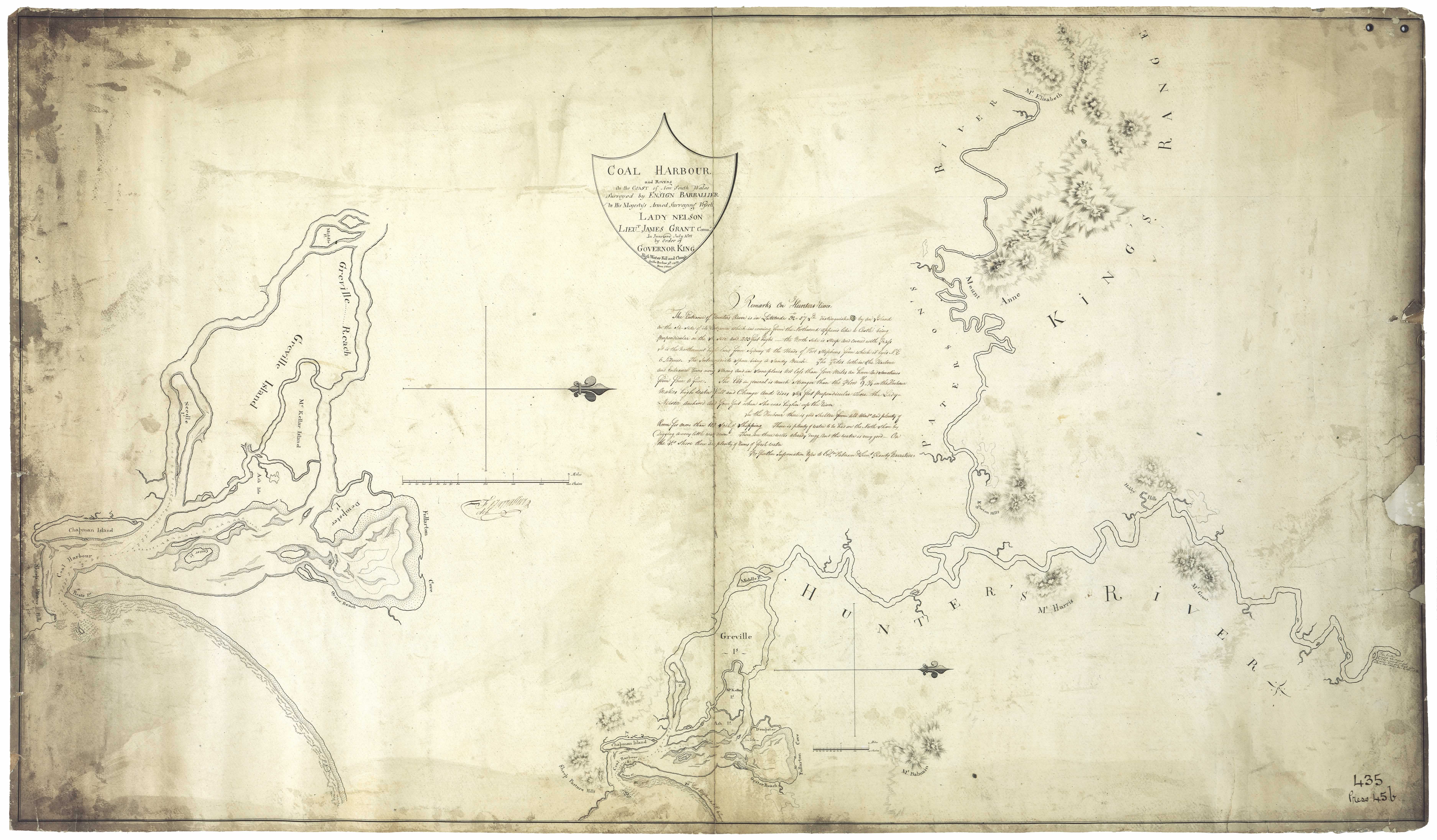
Pirate's Point - early name for Stockton. - see Barrallier's 1801 map [31]
Piriwal Cave - Cave on the southern side of Pulbah Island, Lake Macquarie
Pitlochry - Dungog district - named after the seaside suburb of Edinburgh, Scotland
Pitnacree - Named by Rev. William McIntyre after his old home on River Tay, Scotland
Pitnacree Bridge - First bridge across the Hunter River.
Pitoba - a place of pipe clay - Threlkeld [21]
Pit Row, Newcastle - Cook's Hill
Pittown - Later known as The Borehole and then renamed Hamilton
Pit Town Wallsend - originated when Newcastle Wallsend Coal Co. established two rows of houses near its mine
Plashett - Estate of the Robertson family at Jerry's Plains
Plattsburg - Wallsend began as two mining towns, Wallsend and Plattsburg. Derived its name from the fact of the first sub division being a portion of the land known as Platt's Estate. Used to be known as The Co-Operative
Platts Channel - The channel between land owned by John Laurio Platt and Spit Island
Pockataroo - situated in the district of Liverpool plains at the junction of the Gwydir and Karaula rivers. Run of James Reid. Run of Standish Callaghan
Pokataroo (aboriginal Bukkitaro meaning river going, wide)
Podgewoy (Budgewoi) - A narrow strip of land separating Tuggerah lakes
Poggy - Cassilis district. Aboriginal meaning - wild jassamine [46]
Poggy Forest - Co. Brisbane near Krui River
Point Bass, Newcatle- Named after Surgeon George Bass discoverer of Bass Strait
Point Flinders, Newcastle - Named after Lieut. Matthew Flinders
Point Kent, Newcastle - named by Lieutenant Shortland in 1797 after Lieut. Kent commander of H.M.S. Supply. Now known as Stockton
Point Morisset - Cams Wharf
Point Wolstonecroft - also known as Little Wangi; also known as Chainbibber. On Henry Dangar's 1828 map marked as Ngoroinbah
Pokolbin - a parish in County of Northumberland bounded on the N. by the parishes of Ovingham, Rothbury and Allandale; and S by Ellalong. Singleton district. Drayton family 1850s.
Polbue Creek - Barrington Tops
Pomby Creek - West Tributary of Paterson River, flowing into it 12 miles north of Hinton
Pommy Town - Mayfield East. English workers' homes. 1921
Pondee Point - Toronto
Poole Farm - Farm belonging to Montague Parnell 1/4 mile from Maitland
Popran - a creek situated in Co. of Northumberland; branch of Mangrove creek
Porcher St. Newcastle - named after Henry Porcher, one of the first directors of the A.A. Company [3]
Porcher's River - flows in to Carrington River (see Dangar's map)
Porphyry Point - vineyard north of Seaham established by Rev. Henry Carmichael
Portree - Raymond Teerrace district - Named by J. D. Maclean after Portree in Isle of Skye, Scotland [46]
Port Stephens - Named by
Captain James Cook
Captain Cook is one of the greatest navigators and explorers of all time. He mapped the east coast of Australia in H.M.S. Endeavour and during this voyage sailed north past Nobbys at the mouth of the Hunter River on 10th May 1770
on May 11, 1770 after Philip Stephens, Secretary to the Admiralty. Situated in Co. of Gloucester. Entrance points named Yacaba and Tomaree. Early Days in Port Stephens.PothanaBranxton district - Aboriginal meaning - smoke [46]
Premer - Run at Liverpool Plains taken up by Nelson Simmons Lawson
Presqueville - near Maitland. Estate of Wakefield Simpson
Princes Bay - Toronto - Bay which runs along Brighton Av. In 1920 the Prince of Wales stayed at Craig Royston on the waterfront here
Prospect Cottage - near Maitland
Prospect Hill - early name for suburb of Newcastle known as The Hill
Pudgewoy Hill - Co. Northumberland - a hill lying to the NW of Tuggerah Beach Lake in the parish of Wallarah. [37]
Puenbuen - small stones (aboriginal meaning).[24] Estate belonging to John Bingle west of Aberdeen
Puenbuen - a mountain situated in Co. of Brisbane on the left bank of Dartbrook
Pulbah - Lake Macquarie. Approx 150 acres. (Bulba - Aboriginal name for an island; any place surrounded with water); also Boroyirong; also Boorayurroon. [33]
Pullaming - in the district of Liverpool plains on the Mooki 64 miles from Murrurundi. Estate of J. Brown
Pumby Creek Co. Durham a small western tributary of the Paterson River
Pumpkin Creek - Dungog/Gloucester district - said to be called so after a teamster upset a load of pumpkins on his way to Cobark diggings and the pumpkins rolled down a steep hill
Pumpkin Point - a bend in the Karuah River
Pump Station Creek - Liverpool Plains
Puna Rd - Wangi. (Aboriginal meaning sea sand) - from Israel's subdivision map c. 1923
Punby Brook - also Pumby Brook. Flows in to the Paterson river near Tocal. -see Dangar's map[29]
Puntei - a narrow place; the name of any narrow point of land - aboriginal meaning - Threlkeld [21]; also Derahbambah - land on which Ebenezer was built - Toronto Lake Macquarie
Puntelva - Hill at the Myall River (Teggs: 1842)
Puntolba also Bendolba, Dungog district. (see Trove)
Purandarra Brook - Flows in to the Hunter R. County of Belford. - Dangar's Map [29]
Purranville - creek situated in district of Liverpool plains; branch of the Conadilly
Purribagba - Ants nest place. - Threlkeld [21]
Putty - (aboriginal meaning fish) [46]; situated in Co. of Hunter.
Putty Creek, or the Tupa, rises in north at the foot of Mt Kindarun, and runs the length of the valley before joining with the Wollemi Creek which then feeds into the Colo River.
Putty Road - alternate name for Howe's road; also formerly Bulga Road
Pyong - a creek in district of Liverpool plains; on this stream was the station of Helenus Scott
Pyrambango Mount - Co. Parry - a peak of the Peel Range lying on the S bank of the Namoi River 4 miles from Carroll.
Q
Quambi - former school built in 1831, Stroud
Quart Pot - Dungog district. Aboriginal name Codaget
Queens Wharf - Morpeth - named after Her Majsty Queen Victoria [46]
Quorrobolong - Cessnock district. 6 miles from Millfield. [37]
Quigley Estate - Booragul; Teralba
Quinalup - Street at Gwandalan, Lake Macquarie (aboriginal meaning happy place)
Quintambone - in the district of Liverpool Plains on the Namoi river. H. Cox's station
Quirindi - Aboriginal meaning dead tree on mountain top.[46] Quirindi, postal town situated on the Quipolly and Jacob and Joseph Creeks. [37]
Quoipolly - situated in the district of Liverpool Plains on a branch of the Purranville creek. Wells Gazetteer 1848
Quorrobolong - Cessnock district
Quotabra - a township on the South bank of the Namoi River
Notes on the Origins and Locations of the Hunter Region has been derived from the following sources
[1] Trove - National Library of Australia
[2] Newcastle Morning Herald 11 December 1954
[3] The Newcastle Sun 2 May 1918
[4] The Newcastle Sun 26 January 1931
[5] The Many names of Newcastle Mulumbinba
[6] The Muswellbrook Chronicle 8 November 1899 ( native names of place from black tracker Jimmy of Muswellbrook)
[7] Lake Macquarie History of Places
[8] Cadell, F.A., Survey of Newcastle, Journal and Proceedings of the Royal Australian Historical Society, 1936
[9] Davies, Noel, Convict Nobbys : the story of the convict construction of Macquarie's Pier and the reconstruction of Nobbys Island
[10] Historical Roads of New South Wales
[11] Keith H. Clouten, Reid's mistake : the story of Lake Macquarie from its discovery until 1890
[12] County Electors in Newcastle 1855
[13] Hunter Estates Comparative Heritage Study
[14] The Dungog Chronicle 6 July 1949
[15] The Scone Advocate 24 July 1894 (Muswellbrook names)
[16] Wingham Chronicle 13 November 1931 (Manning River places)
[17] King Tom's Aboriginal Geography in Memorandum of E.C. Close, in Australian Town and Country Journal, 12 January 1878, p. 8.
[18] Aboriginal names, Australian Town and Country Journal 11 January 1879p. 17
[19] Henry Thomas Ebsworth papers, June 1825-February 1827; with illustration and maps
[20] Horsemen of the First Frontier (1788-1900) and the Serpent's Legacy Front Cover Keith Robert Binney
[21] An Australian Language as spoken by the Awabakal, the people of Awaba, Lake Macquarie, being an account of their language, traditions and customs - Lancelot Threlkeld (many of the aboriginal terms above have come from this source which is probably the language of the lower Hunter tribes)(many of the aboriginal terms above have come from this source which is probably the language of the lower Hunter tribes)
[22] Hunter Living Histories - Ludwig Leichhardt in Newcastle
[23] A geographical dictionary or gazetteer of the Australian colonies ... By William Henry Wells
[24] Placenames as a guide to language distribution in the Upper Hunter - Jim Wafer
[25] Lake Macquarie : past and present
[26] Wangi Wangi Street Names by Clive Read
[27] Forgotten place names of Lake Macquarie - Lake Macquarie Library online
[28] Lake Macquarie: Parish of Awaba, County of Northumberland, Shire of Lake Macquarie. Parish map in 4 sheets and reference sheet: South East Sheet
[29] Map of the Hunter River and its branches by Henry Dangar 1828
[30] Robert Dixon's 1837 Map - Trove
[31] Ensign Francis Barrallier's Map 1801 - Hunter Living Histories
[32] Australian Town and Country Journal 22 November 1873
[33] Procter's Sketch 1841 - Hunter Living Histories
[34] Tegg's Pocket Almanac
[35] Map of Young Wallsend (Edgeworth) showing Salty Creek Recreation Area, c.1920. Scanned from: Road and tourists' map of Lake Macquarie and environs, H. E. C. Robinson Limited, Sydney.
[36] Salty Creek Recreation Area
[37] Geographical Encyclopaedia of New South Wales
[38] Atlas of the settled counties of New South Wales - State Library NSW
[39] Maitland Weekly Mercury 4 July 1896
[40] Empire 3 Dec 1853 Lecture on the Kamilaroi Blacks (Rev. William Ridley)
[41) Israel's subdivision map of Wangi c. 1923. State Library of NSW
[42] Hunter 2000, National Trust of Australia (NSW), 1973
[43] Lauchland, E. S., Homes we Visited - Dumore. Newcastle & Hunter District Historical Society Journal, 1947 p. 39
[44] Boyle's Lower Hunter index, 1801-1883 (Harry Boyle)
[45] Hunter Valley Place Names and their Meanings, Newcastle Library, Archived 14 June 2011 at the Wayback Machine
[46] Toponomy: Place Names of New South Wales: Their Origin, Meaning and Locality, compiled by J. Carlos W. Stretch
[47] Rediscovering the Coquun: towards an environmental history of the Hunter River. Address given at the River Forum 2000 at Wyndham Estate, Hunter River; by Glenn Albrecht PhD, Senior Lecturer in Environmental Studies, The University of Newcastle
[48] How Many Inventors? Russell Rigby, Hunter Living Histories, 10 October 2017
↑