Notes on the Origins and Locations of Place Names
Newcastle - Lake Macquarie - Hunter Valley
H
Hacking Point/ Island - Early name for Nobbys. Named by Lieutenant Shortland in 1797 after Quartermaster Hacking of H.M.S. Sirius
Hall's Creek - Co. Brisbane; flows into the Goulburn river
Hall's Hill - steep hill near the junction of the Dungog and Gloucester roads named after Charles Hall superintendent of Australian Agricultural Co.
Halliday's Point - Co. Gloucester, a sandy beach lying about half way betwen Cape Hawke on the S and Farquhar inlet on the N. [37]
Hallsborough - Maitland - House of William Hall a Waterloo veteran of Maitland
Halton - Co. Durham 160 miles N of Sydney. [37] Named after a place in Sussex, England [46]
Halton Estate - Allyn River
Hambledon Hill - Singleton district. Various owners - Henry Nowland, Mr. Dines, Augustus Hooke, Mr. Dunster.
Hamilton - Suburb of Newcastle. Named after the residence of William M. Carlyle Secretary of the A.A. Company which was named after Edward Hamilton, Governor of the A.A. Company 1856 - 98. Previously known as Pittown and The Borehole.
Hampton Estate - Left bank of Cockle Creek. Argenton, Lake Macquarie
Hampton Park - Jerry's Plains. Estate belonging to Peter Duff in 1838
Hams Beach - Caves Beach - named after William Henry Ham, first resident
Hanbury - early name for Waratah. Named by Thomas Grove after his birthplace in Staffordshire England.
Hanging Rock - Gold fields near Nundle. Land originally taken up by Nathan Burrows in 1848. Co. Parry, situated on the Oakenville Creek, the rivers Peel Barnet, and Manning taking their rise in the surrounding mountains. [37]
Hanging Rock Creek - Co. Parry - a small auriferous eastern tirbutary of the upper end of the Peel River rising in the western slope of the Australian Alps and flowing into the main stream between Nundle and Dungowany. [37]
Hanging Rock - Co. Northumberland - a remarkable block of red sandstone on the bank of the Wollombi Brook No. of Mount Colabeen. [37]
Hanley's Creek - North of Dungog
Hannan Street Maitland - Named after John Hannan
Hannan House Maitland
Happy Flat - Hamilton from Steel Street to Turner Street
Happy Valley - Co. Parry - an auriferous gully lying between Wallabadah and Hanging Rock
Harben Vale - in the Co. of Brisbane on Page's river 4 1/2 miles from Murrurundi. Estate of William Henry Warland
Hardwick Range - Liverpool Plains
Hardys Hill - Name given to the hill at Speers Point which was the site of an old council quarry
Harrowby Estate - Wollombi Brook. A grant to John Tremayne Rodd (see Dangar's Map)
Hartfell - formerly known as the Gunnedah run owned by Johnston at Gunnedah
Harthill Farm - property of Rev. J.H. Garven near Maitland
Hartley Coal Mine - Lake Macquarie 1870
Hatfield Park - farm 4 miles from Dungog
Hat Hill - Co. Northumberland. [37]
Hathorn's River - flows into Carrington River (See Dangar's map)
Hawke Cape - Co. Gloucester - a rocky promontory 16 miles to the N. of Sugarloaf Point. [37]
Hawke Cape - Settlement. Co. Gloucester - lies on the Maclan and Wollombi Rivers on Lake Wallis. [37]
Hawkes Nest - Co. Durham - 148 miles N Sydney. [37]
Haydonton - a private town situated in Co. Brisbane across the Page River from the town of Murrurundi. See Thomas Haydon
Heatherbrae - Suburb of Port Stephens near Raymond Terrace
Heaton - Cessnock district
Heaton's Gap - also known as Brunkerville Gap or The Gap - a pass over the Watagan Mountains
Heatonville - a timber getting settlement south of The Gap now known as Freeman's Waterholes
Hebburn - After a suburb of Newcastle-on-Tyne
Hebden - Singleton district. Named after a place in Yorkshire England [46]
Hecknadiiey - Aboriginal name for the pass over the Liverpool Ranges
Heddon - a parish in Co. Northumberland bounded on the N. by Gosforth; S. by Stanford; E. by Maitland and Strockrington and W. by Allandale.
Heddon Greta - village established near a coal mine Heddon is named after a place to the west of Newcastle-on-Tyne. Greta is named after the seam of coal discovered by Professor David [46]
Hernani - Wollombi district. Named after places in Spain [46]
Hexham - Newcastle suburb. Grant to Edward Sparke in 1820';s. Situated Co. Northumberland half way between Newcastle and Maitland. Named after market town of Hexham, England
Hexham Swamp (Aboriginal name Burraghihnbihng) - Territory of the Pambalong or Big Swamp Tribe. - A large tract of marshy land between Hexham and Minmi - [37]
Hide's Creek - Co. Parry - a small auriferous tributary of the Peel River joining it at Bowling Alley Point diggings. [37]
Highfields - Newcastle suburb. First subdivided by John Isaac Cotterill in 1920 (Lake Macquarie History)
Highgate - Barnsley - early subdivision c. 1880
High Street, Newcastle - Lieut. Charles Jeffreys of the brig Kangaroo produced a survey map in 1816 naming the one street in the Coal River settlement as High St. This later became Watt St.
Higham Road - Co. Northumberland. A township 4 miles from Waratah. [37] Named after a place in Kent England [46]
Hilldale - Paterson district, descriptive [46]
Hillrock - estate 8 miles up the Rouchel Brook
Hillsborough - Estate of Beresford Hudson - Hunter River near Maitland. Named after a place near Belfast, Ireland [46]
Hillsborough - Named after an early landholder of Lambton Dr. John James Hill. Situated at Lake Macquarie
Hillsend Farm - Also known as Greig's Farm. Upper Hunter
Hillside - property north of Dungog
Hinnes Craigs - Gloucester
Hinton - Co. Durham, parish of Hinton at the junction of Paterson and Hunter Rivers and to the S of the Mount Royal ranges. [37]
Hinton Estate - Adjoining the Bowthorne Estate. A grant of 640 acres to Robert Coram Dillon. Named after Dillon's ancestral home in England
Hobart Place - residence of F. J. Shaw, Mayor of Newcastle 1876
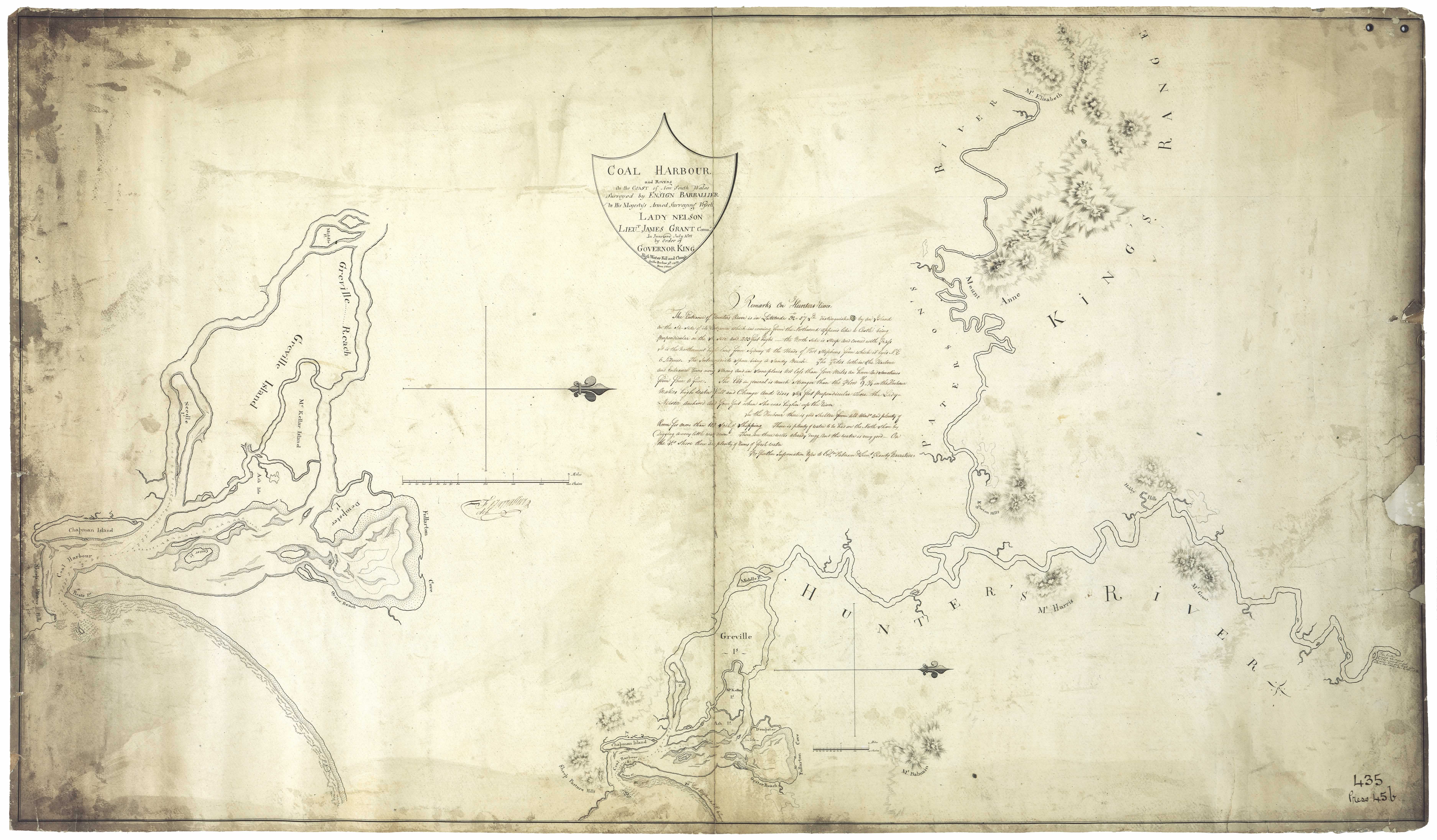
Hobby Hill - situated near Hunter River downriver from Maitland - mentioned on Barrallier's 1801 map in HR NSW p. 420
Hoddle - Mountain situated in the district of Liverpool Plains between the Rivers Peel and Turrabeile
Hogg Island - (Former) Island in the Paterson River
Holdsworthy Downs - Situated just above the confluence of the Dartbrook with Kingdon Ponds in Co. Brisbane (See Dangar's map). About a mile to the W. of Scone
Holkham/ Holkam - In the county of Brisbane on the Hunter River 5 miles from Scone. Estate of Henry Dangar
Hollydene - Denman district [46]
Hollow Tree Farm - Bounded on the land belonging to Siddons and Peppercorn 1841. Charles Croaker. See Hunter Valley Settler Map1. Subdivison in 1892 adjoined Raymond Terrace Racecourse
Holmesville - West Wallsend district. Named after a resident, a miner Joseph Holmes [46]
Holmwood - Private residence of the Rusden family in West Maitland
Homebush - Estate of John Field
Honeysuckle Point - name given to area adjacent to Newcastle Harbour because of native plant resembling honeysuckle flower [3]
Hookanvil Creek - Vicinity of Hanging Rock. Also known as Ogunbil Creek, Oakey Creek, Oakenville Creek and Hanging Rock Creek.
Hope Cottage - near the Long Bridge Maitland
Hopewell Cottage - Cottage on the Bowthorne Estate
Horning Creek - Co. Northumberland - a small tributary of the estuary of the Mangrove Creek. [37]
Horseshoe Beach - beach at Newcastle
Horton - Parish in Co. Gloucester bounded on the North by Thalaba; S. by Wilmot; E. by Karuah and W. by the Williams River.
Horton Park - Muswellbrook district
Howe's Valley - After John Howe, who, with Benjamin Singleton discovered Patrick Plains on 17 March 1820.
Howick - a parish in Co. Durham bounded on the W. by Wynn; S. by the Hunter River and E. by Ravensworth.
Humumba - Run belonging to Edward and George Rouse at Liverpool Plains
Hungry Flat - Co. Northumberland. A flat on the Great North Road from Sydney to Maitland at Mangrove Creek. See Dixon's map
Hungry Hill - Paterson
Hunniford lane, Newcastle - Named after a contractor of that name. [3]
Hunter's Hill - Estate of Timothy Nowlan. Later known as Eelah
Hunter National Park - Plateau south of Hunter and Goulburn Rivers to the northern watershed of the Hawkesbury River
Hunter Range - a branch of the Blue Mountain Range separating the tributaries of the Hawkesbury from those of the Hunter.
Hunter Street - and Hunter Street West originally consisted of Hunter Street to Brown Street, Blane Street from Brown Street to Cottage Creek, thence Charlton Street to the western boundary of the city. All that portion of the thoroughfare known as Hunter street West was named by the A.A. Co , Blane street (from the Bank of Australasia to the old Cottage Creek) after Mr. Blane who as deputy-governor in 1850, sailed for Port Stephens to facilitate the sale of land and settlement of the estate there. From Cottage Creek to the western boundary of Newcastle, the continuation of Blane street, was known as Charlton street. Mr. Charlton was one of the overmen at the pits and with Mr. Steele took charge of the colliery working after the going of the manager Mr. Plews, who succeeded Mr. Brown. [3]
Hunter's River - Named after Governor John Hunter by Lieut. John Shortland. For many years known as the Coal River. (Aboriginal name Coquun; Myan or Coonanbarra) Also Gingamboon.
Hunter Street, Newcastle - previously known as Blane Street.[3]
Huthfield - Mulberry Creek
Notes on the Origins and Locations of the Hunter Region has been derived from the following sources
[1] Trove - National Library of Australia
[2] Newcastle Morning Herald 11 December 1954
[3] The Newcastle Sun 2 May 1918
[4] The Newcastle Sun 26 January 1931
[5] The Many names of Newcastle Mulumbinba
[6] The Muswellbrook Chronicle 8 November 1899 ( native names of place from black tracker Jimmy of Muswellbrook)
[7] Lake Macquarie History of Places
[8] Cadell, F.A., Survey of Newcastle, Journal and Proceedings of the Royal Australian Historical Society, 1936
[9] Davies, Noel, Convict Nobbys : the story of the convict construction of Macquarie's Pier and the reconstruction of Nobbys Island
[10] Historical Roads of New South Wales
[11] Keith H. Clouten, Reid's mistake : the story of Lake Macquarie from its discovery until 1890
[12] County Electors in Newcastle 1855
[13] Hunter Estates Comparative Heritage Study
[14] The Dungog Chronicle 6 July 1949
[15] The Scone Advocate 24 July 1894 (Muswellbrook names)
[16] Wingham Chronicle 13 November 1931 (Manning River places)
[17] King Tom's Aboriginal Geography in Memorandum of E.C. Close, in Australian Town and Country Journal, 12 January 1878, p. 8.
[18] Aboriginal names, Australian Town and Country Journal 11 January 1879p. 17
[19] Henry Thomas Ebsworth papers, June 1825-February 1827; with illustration and maps
[20] Horsemen of the First Frontier (1788-1900) and the Serpent's Legacy Front Cover Keith Robert Binney
[21] An Australian Language as spoken by the Awabakal, the people of Awaba, Lake Macquarie, being an account of their language, traditions and customs - Lancelot Threlkeld (many of the aboriginal terms above have come from this source which is probably the language of the lower Hunter tribes)(many of the aboriginal terms above have come from this source which is probably the language of the lower Hunter tribes)
[22] Hunter Living Histories - Ludwig Leichhardt in Newcastle
[23] A geographical dictionary or gazetteer of the Australian colonies ... By William Henry Wells
[24] Placenames as a guide to language distribution in the Upper Hunter - Jim Wafer
[25] Lake Macquarie : past and present
[26] Wangi Wangi Street Names by Clive Read
[27] Forgotten place names of Lake Macquarie - Lake Macquarie Library online
[28] Lake Macquarie: Parish of Awaba, County of Northumberland, Shire of Lake Macquarie. Parish map in 4 sheets and reference sheet: South East Sheet
[29] Map of the Hunter River and its branches by Henry Dangar 1828
[30] Robert Dixon's 1837 Map - Trove
[31] Ensign Francis Barrallier's Map 1801 - Hunter Living Histories
[32] Australian Town and Country Journal 22 November 1873
[33] Procter's Sketch 1841 - Hunter Living Histories
[34] Tegg's Pocket Almanac
[35] Map of Young Wallsend (Edgeworth) showing Salty Creek Recreation Area, c.1920. Scanned from: Road and tourists' map of Lake Macquarie and environs, H. E. C. Robinson Limited, Sydney.
[36] Salty Creek Recreation Area
[37] Geographical Encyclopaedia of New South Wales
[38] Atlas of the settled counties of New South Wales - State Library NSW
[39] Maitland Weekly Mercury 4 July 1896
[40] Empire 3 Dec 1853 Lecture on the Kamilaroi Blacks (Rev. William Ridley)
[41) Israel's subdivision map of Wangi c. 1923. State Library of NSW
[42] Hunter 2000, National Trust of Australia (NSW), 1973
[43] Lauchland, E. S., Homes we Visited - Dumore. Newcastle & Hunter District Historical Society Journal, 1947 p. 39
[44] Boyle's Lower Hunter index, 1801-1883 (Harry Boyle)
[45] Hunter Valley Place Names and their Meanings, Newcastle Library, Archived 14 June 2011 at the Wayback Machine
[46] Toponomy: Place Names of New South Wales: Their Origin, Meaning and Locality, compiled by J. Carlos W. Stretch
[47] Rediscovering the Coquun: towards an environmental history of the Hunter River. Address given at the River Forum 2000 at Wyndham Estate, Hunter River; by Glenn Albrecht PhD, Senior Lecturer in Environmental Studies, The University of Newcastle
[48] How Many Inventors? Russell Rigby, Hunter Living Histories, 10 October 2017
↑