Free Settler or Felon
Convict and Colonial History


Hunter Valley Settlers - Map 1


Click on any of the names on the map or select from the links below to find out more about settlers on this map
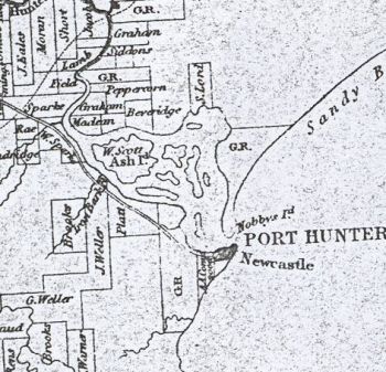
Ash Island - Alexander Walker Scott John Laurio Platt Australian Agricultural Company Joseph Weller George Weller William Brooks Jonathon Warner George Brooks Richard Windeyer and Adam Beveridge William Peppercorn Richard Siddons John Maclean G.T. Graham William Sparke Henry Rae Vicars Jacob Francis Shortt Francis Moran John Eales William Bradridge Edward Sparke John Field George Thomas Graham Early Settler Map 1

A. A. Company

Adam Beveridge

William Bradridge

George Brooks

William Brooks

John Eales

John Field

George T Graham

Vicars Jacob

William MacLean

Francis Moran

William Peppercorn

John Laurio Platt

Henry Rae

James St. John Ranclaud

Alexander W. Scott

Francis Shortt

Richard Siddons

Edward Sparke

William Sparke

Jonathan Warner

Joseph Weller

George Weller

Richard Windeyer

Notes and Links

Old Times Road Notes - from Tegg's Pocket Almanac 1842..........Road from Newcastle Through Maitland:

Newcastle is beautifully situated at the mouth of the Hunter, and although there is a church and resident clergyman, a Government house, gaol, stores and hospital, and numerous allotments laid out; the place has not increased much until lately, the preference having been given to Maitland, at the head of the navigation. There is an inn at Newcastle called the Ship Inn, and now the town is making rapid progress. Opposite Newcastle is a low sandy point, and there is an interrupted sandy beach of eighteen or twenty miles extent, by which you may travel to the southern shores of Port Stephens; there are the grants of Cromarty, Blackford, and Lieutenant Caswell R.N. called Tenilba. From the south shores you may cross the harbour of Port Stephens to Carrington on the north; or, head the harbour, and cross the Karuah.

1 1/2 From Newcastle on the right is a Government cottage lately purchased by Mr. Weller, where the road crosses a small stream

3. Cross another stream

4 1/2 Enter Platt's Farm; the road approaches the banks of; the road approaches the banks of the Hunter opposite Ash or Greville Island on which a grant has been recently selected by A.W. Scott Esq.,

8. Cross Iron Bark Creek. This creek is navigable for three or four miles, a low range divides it from Cockle Creek, a stream running into Lake Macquarie, also navigable; at the heads of these creeks are the grants of the Messrs Weller, Mr and Mrs. Brooks, Maziere and others

The road passes through a village reserve. Enter Spark's farm; to the left is a large swamp called Barrabinebin, where the locations commence and the whole country to the west is granted, and improvements present themselves on every side.

Hunter Valley Place Names
11. On the right Sparke's Inn. Here the Hunter bends to the north east for five or six miles, it then receives the waters of the William and again resumes its easterly direction.

13 Meet the track from Wollombi to Port Stephens by Tomalpin Hill

14. On the right cottage on Cummings' grant.

16. Bridge across Four Mile Creek. Enter the town of Maitland; the ground is favourable for the formation of a large town and much pains have been bestowed on laying it out, many allotments have been located and a school house and chapel erected; but the preference has been given by builders to the low lands on the other side of Wallis Creek, these are however subject to flood and ere long, the houses may be washed away and the superior situation of the new town will then be made evident, more especially when the population shall have become sufficiently numerous to admit of the development of the whole plan, such as cutting a canal from near the store ship to Wallis Creek....

On the right is the Rose Inn, built by the late Alexander McLeod Esq., also the road to the St. Michael Store Ship, distant about three miles but the distance by water, owing to the winding of the river is about twelve miles; a new road has been made by an iron gang, between Maitland and the St. Michael wharf which was commonly called the Green Hills, and a site for a public wharf has been obtained from Mr. Close the proprietor of the land in that vicinity; on the left is the track through Allman's and Maughan's farms, towards Mulbering and Brisbane Water; and joining the tracks to Tomalpin Hill, leading to the Wollombi.

19 1/2 Bridge over Wallis' Creek, on either side of this bridge, on the banks of the river, are the small farms which were allowed to those who had cultivated here when this was still a penal settlement. The bridge fell in last year, and a new one has been erected, also of wood, this being no very favourable place for the construction of a stone bridge, the alluvium affording no good foundation, and the banks being sometimes many feet under water. The most remarkable change effected in the neighbourhood has been the successful draining by Mr. Houston Mitchell according to a plan suggested by his brother of an extensive lagoon left by flood, which overwhelmed his crops for three seasons; 340 acres have thus been recovered of the richest alluvial soil, unencumbered by a single stump or other obstacle to the plough.

21. The navigation of the Hunter ends; on this spot are various inns, and a mass of houses have been built, mostly upon the small original grants before alluded to as belonging to the first cultivators. To the north and south veterans have been lately located; Messrs Blaxland, Bowman and Sempill have wharfs here, and there is a great disposition to build, a considerable population being there already.

At this spot is the ford across the Hunter to Paterson's Plains being the branch of the Great North Road from Wollombi to Port Stephens; this ford is about 124 1/2 miles from Sydney by the new roads. Maitland Mercury 15 October 1887


Journey to the Hunter by Steamer 1831

Newcastle in 1829

Newcastle in 1828

Maitland History