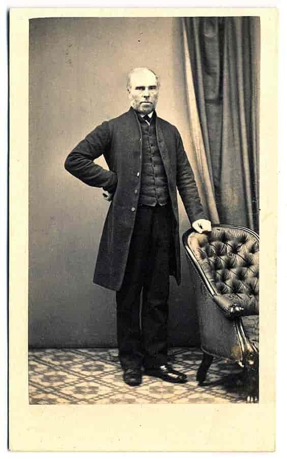
Robert Dixon - Surveyor
Image: Robert Dixon - University of Tasmania
In 1929 seventy-eight year old Bendemeer resident Robert Dangar Dixon, the youngest son of Robert Dixon, made available manuscript and papers that revealed some of the details of the life of his father Robert Dixon a well-known surveyor of the 1830s and 1840s.
A summary of the papers was published in the Sydney Mail:
Surveyor Robert Dixon was born at Cockfield between Stockton and Darlington, Durham, England on 4th April 1800.
His father John Dixon was either an owner or manager of a coal-mine. His comfortable circumstances allowed his sons to adopt professional careers. Robert Dixon's brother Thomas was a chemist.
Among the relics once treasured by Robert Dangar Dixon was a fine photograph, which was taken from a lithograph of an original drawing executed by his father Robert. This drawing was produced by surveyor Robert Dixon when he was only twelve years old, and depicts the family home at Cockfield.
Van Diemens Land
Brothers Robert and Thomas Dixon arrived in Van Diemen's Land on the Westmoreland in 1821. For two years they were employed by Edward Lord, in charge of his extensive stockyards. In 1823 each brother was granted 100 acres in the valley of the River Clyde and in 1824 each received an additional 200 acres.[1]In July 1826 Robert Dixon sold out to his brother and moved to New South Wales where he was employed as assistant-surveyor in the Surveyor General Department. He surveyed a portion of the coastal area south of Sydney near Cronulla.
Services as Surveyor 1831 - 1832
The following statement outlining Dixon's services can be found in the Historical Records of Australia, Vol. XVIII, p. 454Mr. R. Dixon to Surveyor-General Mitchell.
Sydney. 18th July. 1836.
Sir, With reference to your memo, of 15th Inst, requesting to know the date of my appointment, also the several general instructions received by me, and the nature of the duties consequent thereon, in order to enable you to reply to the Colonial Secretary's letter No. 36/578, I have the honor to inform you that I joined the Surveyor General's department as Assistant -Surveyor in September 1826.
My first employment was about Sydney and its environs, after which I proceeded to Illawarra in an open Boat and surveyed the Coast from thence to Botany Bay, taking up Port Hacking, the Southern Shores Botany Bay. George's River and its branches. I was then ordered to survey the unmeasured grants in the Cowpastures, and to extend the survey to Burragorang. Werraberri Creek, the Notai River, part of Coxes river, the Warragumba find the Wollondilly to Goulburn Plains which I accordingly did: this includes the principal duties performed under Mr. Oxley.
My next instructions were from Major Mitchell to join him in the Trigonometrical Survey of the Colony, when I accompanied him over the Southern districts on that duty and have since extended angles over the whole Colony. In the interim I completed the trace of the principal features South and South West of Goulburn Plains, including Lakes Bathurst and George, the Molonglo River, part of Murrumbidgee, the Yass River, Narrawa and Lachlan Rivers, and several of their branches, as well as the dividing range from Burrah Burrah to Lake George, and also a great many Grants in the Southern Counties.
My next movements were in the Western Districts, where I completed a detailed survey of the whole Mass of broken country between Mount Victoria and Bathurst, previously to Major Mitchell's laying out the new line of road between these points; after which I was engaged in measuring grants in that neighbourhood and on the Lachlan River, etc. These were the principal Instructions received and duties performed by me up to the beginning of the year 1831 : but there were many works of minor importance, particularly farms in the County of Cumberland, etc.
In the year 1831, I received instructions to proceed to the Upper Hunter River districts for the purpose of laying down the principal features in the North West Districts. I commenced by measuring a Base line on Liverpool Plains of three miles in length, from which I fixed the principal heights in that part of the Colony, and was enabled to connect, these points with the former Trigonometrical Survey. I then traced the whole of the dividing range from the head of the Coolahburragundy Stream to Mount Royal, and thence to Mount Arthur. I then took up the survey from the head of Page's River across Liverpool Plains to Peel's River, shewing the courses of the principal Ranges and Streams in that country: after which, I laid down the Whole of the Upper Hunter's River from its confluence with the Goulburn to its source, including its several branches, the Page, Kingdown Ponds, Dart Brook, with many minor tributaries and a great number of Grants and purchases thereon. I also completed a detailed survey of the country between Patrick's Plains and Muscle Brook, likewise between Leamington and Muscle Brook, shewing the old lines of road between those points previously to the Surveyor Generals making the new line of road from Leamington to Muscle Brook, which line I have since surveyed.
I was then engaged in the survey of the principal streams in the Counties Brisbane and Bligh, viz., the Wybong, Gungal. Gummum, Bogibri. Krui, Munmurra, Talbragar and Coolahburragundy. with the whole of the Grants and purchase on those Streams with a few exceptions.
In the Month of October, 1833, I received Instructions from Major Mitchell when at Maitland to go to Wellington Valley with my equipment and from thence to explore the unknown country laying to the West, which I accordingly did, and reached the Bogan, followed many miles down that river, and returned to Wellington Valley after having travelled upwards of six hundred miles since my departure from that station. I then came to Sydney for the purpose of re-fitting my equipment. In the Month of May. 1834, I left Sydney for Upper Hunter's River, where I have been employed principally in the measurement of lands for sale and have surveyed since that date two hundred and forty-six thousand, eight hundred and ninety Acres of Land. I have also traced the river Isis, and marked and surveyed a new line of road from Muscle Brook to Liverpool Plains with many other surveys, and, since the period of my appointment, I have not had more than two months' leave of absence from duty.'
Return to England 1836
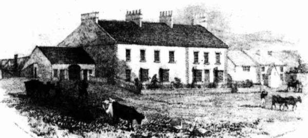 Image: Robert Dixon's childhood home Cockfield
Robert Dixon embarked on the Abel Gower for London in August 1836. [3] In England he was to be married however the young lady would not agree to his leaving England again, so the marriage fell though. In London he published a map of the colony compiled from official surveys and documents. He dedicated his work to Sir John Barrow, president of the Royal Geographical Society.
Return to Australia 1838
He returned to Australian on the City of London in July 1838 however was refused reinstatement by Surveyor-General Sir Thomas Livingstone Mitchell [1]Moreton Bay
On 31st January 1839 it was announced that Moreton Bay was to be thrown open for selection. A Survey Department was established and Robert Dixon was appointed surveyor by Governor Gipps. James Warner and Grenville Chetwynd-Staplyton were appointed assistant-surveyors. [The latter had accompanied Major T. L. Mitchell's expedition to Australia Felix in 1836 as second-in-command. In 1838 Chetwynd-Staplyton worked for Robert Hoddle at Port Phillip. He was murdered by natives in 1840 at a place on the south coast of Queensland. Here a railway station was built and named Staplyton in his honour. ]On 24 July 1839 at Moreton Bay Robert Dixon married Margaret, daughter of John and Ann Sibly of St Neot, Cornwall. Margaret Sibly was the younger sister of Grace Sibly, wife of surveyor Henry Dangar. Robert Dixon was appointed head surveyor in January 1840. A son John Sibly Moreton Dixon was born to Margaret and Robert Dixon in May 1840. John S. M. Dixon was for many years on the staff of the Commercial Banking Company of Sydney. Whilst managing the Kempsey branch of this bank he married Miss Auburn Verge, a sister of Mr. German Verge of the Verge Trust Fund in connection with returned soldiers. Another son William Backhouse Dixon, was a newspaper proprietor.
In 1842, as a result of a disagreement between Lieutenant Owen Gorman (58th regt), commandant at Moreton Bay and Surveyor Dixon, Governor Gipps proceeded to the settlement on the steamer Shamrock to investigate. Other passengers on the Shamrock included Henry Stuart Russell, Major Barney, Watson Parker, Edward Merewether and Commissioner of Crown Lands Simpson.
Governor Gipps decided that Robert Dixon should be dismissed. The charges against Dixon were that he had attempted to incite a mutiny after the arrest of his convict servant and that he had forced a sentry. Dixon denied these charges and made counter-charges of improper conduct against Gorman, who was later relieved of his appointment as magistrate. Lieut. Gorman was to be the last commandant at Brisbane. Robert Dixon was not reinstated to his position at Moreton Bay[1].
Toongabbie
After his dismissal Robert Dixon went to Toongabbie near Parramatta. Here he went in for farming, and his son well remembered hearing his mother speak of the hard times that were experienced.England
In 1844 Robert Dixon received a letter from an uncle in England, Edward Dixon, asking him to go to England as soon as possible. Sufficient surveyors could not be supplied to survey routes fast enough to cope with the great boom in railway-building. Sea travelling was very slow however and by the time Robert Dixon reached England the boom was over. He found employment as line inspector on the railway between Leamington and Rugby and held this position until 1852. By this time, payable gold had been found in Australia sparking the gold rush.Searching for Gold
According to his son, Robert Dixon was appointed manager of the Grand Monarch Gold Mining Company when he declared he knew of likely gold-bearing country in Australia. He arrived in Australia with a man by the name of Webber acting as Secretary and a sum of 500 pounds from the company to defray expenses in the search for gold. He employed a number of miners in the district where the town of Nundle now stands, however the quest was not successful as not enough gold was found to pay for the miners' services and the company fizzled out. He could not pay the secretary's salary with what remained of the company's funds so he returned to England where he successfully sued for the amount owing. [According to an article in the Sydney Morning Herald, the company was called 'The London and Sydney Gold Mining Company'. They did not own land in Australia but had made arrangements with a land owner of upwards of 15,000 acres to be allowed to search for minerals] Sydney Morning Herald 27 July 1852By June 1852 gold had been discovered in the Nundle/ Hanging Rock district sparking a gold rush
Death
The failure of the gold-mining scheme weight heavily on Robert Dixon and from this time until his death on April 8th 1858, he was a confirmed invalid. He was buried in the Camperdown Cemetery, Sydney [2]Notes and Links
1). Monument Australia2). Two of Robert Dixon's Sketches, View of Gummun Plains and Liverpool Range, N.S.W. Taken from Brindley Park (1835) and A View from Camden on the River Nepean, N.S. Wales (undated), were published as lithographs in 1837 by Webb and Son of Snow Hill, London.
3). A Tale of Two Maps - NSW in the 1830's by Mitchell and Dixon: Perfection, Probity and Piracy!. - John F. Brock
4). This map of the colony of New South Wales : exhibiting the situation and extent of the appropriated lands ... dedicated to Sir John Barrow ... by ... Robert Dixon / engraved by J.C. Walker
5). John Dixon, a nephew of the surveyor was the eningeer who supervised the removal of 'Cleopatra's Needle' from Egypt and had it erected on the Thames Embankment in 1878. This huge obelisk weighed 186 tons.
6). Robert Dangar Dixon was former school mate of Australia's first Prime Minister Sir Edmund Barton,
7). Other colonial surveyors mentioned on the Free Settler or Felon site include:
John Armstrong
Francis Barralier
Henry Dangar
Heneage Finch
Charles Grimes
William Harper
Mortimer Lewis
Felton Matthew
Thomas Livingstone Mitchell
John Oxley
James Ralfe
George Boyle White
References
[1] Louis R. Cranfield, 'Dixon, Robert (1800 - 1858)', Australian Dictionary of Biography, National Centre of Biography, Australian National University, published first in hardcopy 1966[2] Sydney Mail 20 November 1929
[3] The Colonist 4 August 1836
↑